You are here: Home > Network List > NE - New England Seismic Network Stations List
> Station FFD Franklin Falls Dam, NH, USA > Earthquake Result Viewer
FFD Franklin Falls Dam, NH, USA - Earthquake Result Viewer
| Earthquake location: |
Near Coast Of Central Chile |
| Earthquake latitude/longitude: |
-30.3/-71.5 |
| Earthquake time(UTC): |
2013/10/31 (304) 23:03:59 GMT |
| Earthquake Depth: |
27 km |
| Earthquake Magnitude: |
6.6 MWW, 6.4 MWB, 6.5 MWC, 6.6 MWW, 6.6 MI |
| Earthquake Catalog/Contributor: |
NEIC PDE/NEIC COMCAT |
|
| Network: |
NE New England Seismic Network |
| Station: |
FFD Franklin Falls Dam, NH, USA |
| Lat/Lon: |
43.47 N/71.65 W |
| Elevation: |
131 m |
|
| Distance: |
73.4 deg |
| Az: |
359.9 deg |
| Baz: |
179.881 deg |
| Ray Param: |
0.05299246 |
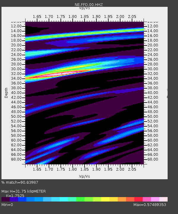
| Estimated Moho Depth: |
31.75 km |
| Estimated Crust Vp/Vs: |
1.75 |
| Assumed Crust Vp: |
6.419 km/s |
| Estimated Crust Vs: |
3.663 km/s |
| Estimated Crust Poisson's Ratio: |
0.26 |
|
| Radial Match: |
90.63987 % |
| Radial Bump: |
291 |
| Transverse Match: |
82.4953 % |
| Transverse Bump: |
400 |
| SOD ConfigId: |
626651 |
| Insert Time: |
2014-04-19 09:03:34.943 +0000 |
| GWidth: |
2.5 |
| Max Bumps: |
400 |
| Tol: |
0.001 |
|

Signal To Noise
| Channel | StoN | STA | LTA |
| NE:FFD:00:HHZ:20131031T23:14:58.173979Z | 3.2620187 | 7.5906456E-7 | 2.3269781E-7 |
| NE:FFD:00:HH1:20131031T23:14:58.173979Z | 2.34327 | 4.966333E-7 | 2.1194026E-7 |
| NE:FFD:00:HH2:20131031T23:14:58.173979Z | 1.005494 | 2.3257282E-7 | 2.3130204E-7 |
| Arrivals |
| Ps | 3.9 SECOND |
| PpPs | 13 SECOND |
| PsPs/PpSs | 17 SECOND |


