You are here: Home > Network List > ZJ12 - Transantarctic Mountains Northern Network Stations List
> Station GRAW East Antarctica > Earthquake Result Viewer
GRAW East Antarctica - Earthquake Result Viewer
| Earthquake location: |
Solomon Islands |
| Earthquake latitude/longitude: |
-6.5/154.5 |
| Earthquake time(UTC): |
2014/12/07 (341) 01:22:00 GMT |
| Earthquake Depth: |
10 km |
| Earthquake Magnitude: |
6.8 MWP, 6.7 MI, 6.8 MI |
| Earthquake Catalog/Contributor: |
NEIC PDE/NEIC COMCAT |
|
| Network: |
ZJ Transantarctic Mountains Northern Network |
| Station: |
GRAW East Antarctica |
| Lat/Lon: |
74.00 S/154.99 E |
| Elevation: |
2205 m |
|
| Distance: |
67.4 deg |
| Az: |
179.84 deg |
| Baz: |
359.425 deg |
| Ray Param: |
0.056975365 |
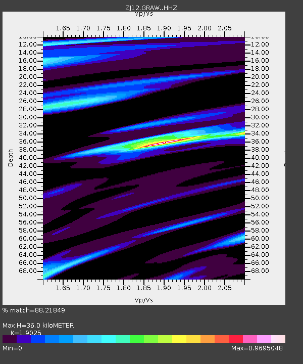
| Estimated Moho Depth: |
36.0 km |
| Estimated Crust Vp/Vs: |
1.90 |
| Assumed Crust Vp: |
6.168 km/s |
| Estimated Crust Vs: |
3.242 km/s |
| Estimated Crust Poisson's Ratio: |
0.31 |
|
| Radial Match: |
88.21849 % |
| Radial Bump: |
400 |
| Transverse Match: |
84.44278 % |
| Transverse Bump: |
400 |
| SOD ConfigId: |
3390531 |
| Insert Time: |
2019-04-15 09:44:13.029 +0000 |
| GWidth: |
2.5 |
| Max Bumps: |
400 |
| Tol: |
0.001 |
|

Signal To Noise
| Channel | StoN | STA | LTA |
| ZJ:GRAW: :HHZ:20141207T01:32:24.769001Z | 8.548327 | 1.4740239E-6 | 1.7243418E-7 |
| ZJ:GRAW: :HHN:20141207T01:32:24.769001Z | 0.8175025 | 1.376157E-7 | 1.6833674E-7 |
| ZJ:GRAW: :HHE:20141207T01:32:24.769001Z | 1.072451 | 3.918721E-7 | 3.653986E-7 |
| Arrivals |
| Ps | 5.4 SECOND |
| PpPs | 16 SECOND |
| PsPs/PpSs | 22 SECOND |


