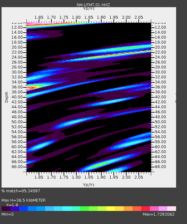
UTMT Martin, TN - Earthquake Result Viewer
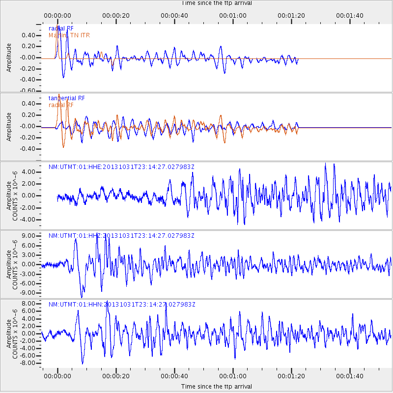
Earthquake location: Near Coast Of Central Chile
Earthquake latitude/longitude: -30.3/-71.5
Earthquake time(UTC): 2013/10/31 (304) 23:03:59 GMT
Earthquake Depth: 27 km
Earthquake Magnitude: 6.6 MWW, 6.4 MWB, 6.5 MWC, 6.6 MWW, 6.6 MI
Earthquake Catalog/Contributor: NEIC PDE/NEIC COMCAT
Network: NM Cooperative New Madrid Seismic Network
Station: UTMT Martin, TN
Lat/Lon: 36.35 N/88.86 W
Elevation: 110 m
Distance: 68.3 deg
Az: 344.986 deg
Baz: 163.886 deg
Ray Param: 0.05638168
Estimated Moho Depth: 36.5 km
Estimated Crust Vp/Vs: 1.60
Assumed Crust Vp: 6.444 km/s
Estimated Crust Vs: 4.027 km/s
Estimated Crust Poisson's Ratio: 0.18
Radial Match: 85.34597 %
Radial Bump: 400
Transverse Match: 83.45404 %
Transverse Bump: 400
SOD ConfigId: 626651
Insert Time: 2014-04-19 09:04:33.326 +0000
GWidth: 2.5
Max Bumps: 400
Tol: 0.001

Signal To Noise

ChannelStoNSTALTA
NM:UTMT:01:HHZ:20131031T23:14:27.027983Z2.9613359.975349E-73.3685313E-7
NM:UTMT:01:HHN:20131031T23:14:27.027983Z1.06889896.0162284E-75.628435E-7
NM:UTMT:01:HHE:20131031T23:14:27.027983Z1.0805016.705574E-76.2059866E-7
Arrivals
Ps3.5 SECOND
PpPs14 SECOND
PsPs/PpSs18 SECOND