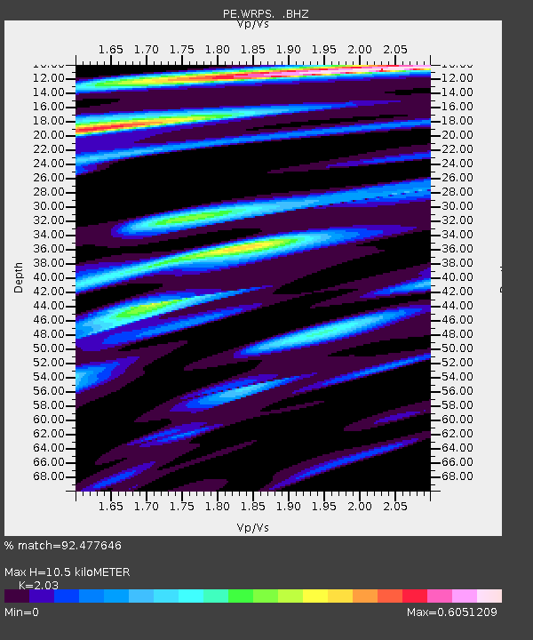
WRPS We R Penn State - Earthquake Result Viewer

Earthquake location: Near Coast Of Central Chile
Earthquake latitude/longitude: -30.3/-71.5
Earthquake time(UTC): 2013/10/31 (304) 23:03:59 GMT
Earthquake Depth: 27 km
Earthquake Magnitude: 6.6 MWW, 6.4 MWB, 6.5 MWC, 6.6 MWW, 6.6 MI
Earthquake Catalog/Contributor: NEIC PDE/NEIC COMCAT
Network: PE Penn State Network
Station: WRPS We R Penn State
Lat/Lon: 40.79 N/77.87 W
Elevation: 320 m
Distance: 71.0 deg
Az: 354.909 deg
Baz: 174.198 deg
Ray Param: 0.054592606
Estimated Moho Depth: 10.5 km
Estimated Crust Vp/Vs: 2.03
Assumed Crust Vp: 6.121 km/s
Estimated Crust Vs: 3.015 km/s
Estimated Crust Poisson's Ratio: 0.34
Radial Match: 92.477646 %
Radial Bump: 331
Transverse Match: 75.66337 %
Transverse Bump: 400
SOD ConfigId: 626651
Insert Time: 2014-04-19 09:05:59.166 +0000
GWidth: 2.5
Max Bumps: 400
Tol: 0.001

Signal To Noise

ChannelStoNSTALTA
PE:WRPS: :BHZ:20131031T23:14:43.680022Z4.6212867.110528E-71.538647E-7
PE:WRPS: :BHN:20131031T23:14:43.680022Z2.57868842.8717827E-71.1136602E-7
PE:WRPS: :BHE:20131031T23:14:43.680022Z1.2765351.4702114E-71.1517204E-7
Arrivals
Ps1.8 SECOND
PpPs5.1 SECOND
PsPs/PpSs6.9 SECOND