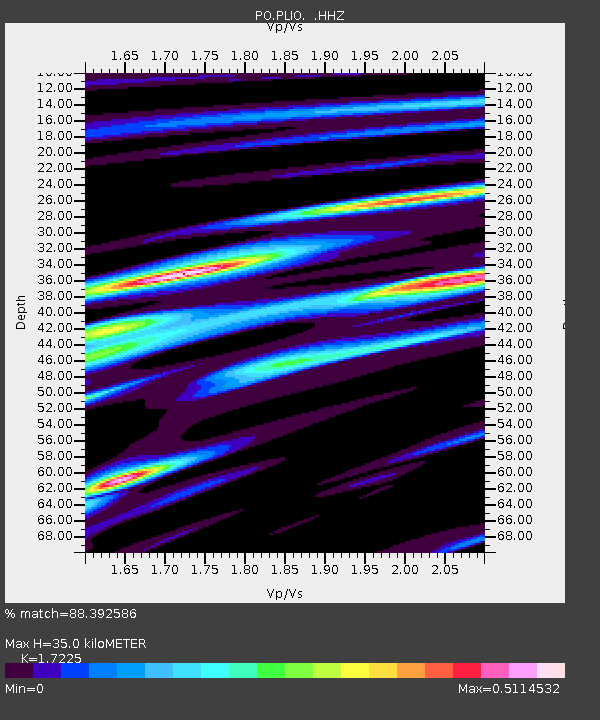
PLIO PELEE ISLAND, ON - Earthquake Result Viewer

Earthquake location: Near Coast Of Central Chile
Earthquake latitude/longitude: -30.3/-71.5
Earthquake time(UTC): 2013/10/31 (304) 23:03:59 GMT
Earthquake Depth: 27 km
Earthquake Magnitude: 6.6 MWW, 6.4 MWB, 6.5 MWC, 6.6 MWW, 6.6 MI
Earthquake Catalog/Contributor: NEIC PDE/NEIC COMCAT
Network: PO Portable Observatories for Lithospheric Analysis and Research Investigating Seis
Station: PLIO PELEE ISLAND, ON
Lat/Lon: 41.75 N/82.63 W
Elevation: 143 m
Distance: 72.4 deg
Az: 351.303 deg
Baz: 169.934 deg
Ray Param: 0.053640686
Estimated Moho Depth: 35.0 km
Estimated Crust Vp/Vs: 1.72
Assumed Crust Vp: 6.498 km/s
Estimated Crust Vs: 3.772 km/s
Estimated Crust Poisson's Ratio: 0.25
Radial Match: 88.392586 %
Radial Bump: 260
Transverse Match: 70.34232 %
Transverse Bump: 400
SOD ConfigId: 626651
Insert Time: 2014-04-19 09:06:54.365 +0000
GWidth: 2.5
Max Bumps: 400
Tol: 0.001

Signal To Noise

ChannelStoNSTALTA
PO:PLIO: :HHZ:20131031T23:14:52.329985Z4.6412453.4206457E-77.370104E-8
PO:PLIO: :HHN:20131031T23:14:52.329985Z2.486611.3091464E-75.2647838E-8
PO:PLIO: :HHE:20131031T23:14:52.329985Z0.8976485.626869E-86.268458E-8
Arrivals
Ps4.0 SECOND
PpPs14 SECOND
PsPs/PpSs18 SECOND