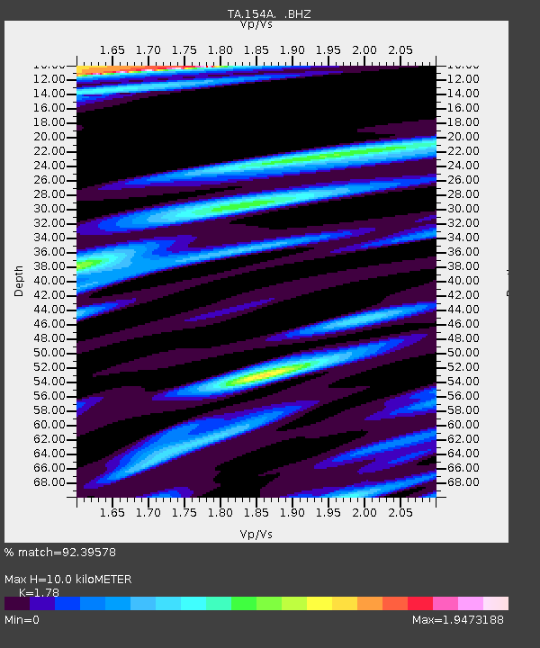
154A Montrose, GA, USA - Earthquake Result Viewer
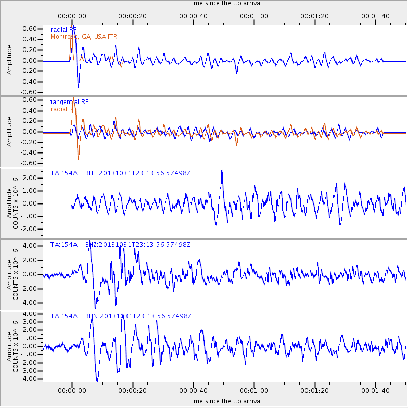
Earthquake location: Near Coast Of Central Chile
Earthquake latitude/longitude: -30.3/-71.5
Earthquake time(UTC): 2013/10/31 (304) 23:03:59 GMT
Earthquake Depth: 27 km
Earthquake Magnitude: 6.6 MWW, 6.4 MWB, 6.5 MWC, 6.6 MWW, 6.6 MI
Earthquake Catalog/Contributor: NEIC PDE/NEIC COMCAT
Network: TA USArray Transportable Network (new EarthScope stations)
Station: 154A Montrose, GA, USA
Lat/Lon: 32.61 N/83.11 W
Elevation: 111 m
Distance: 63.5 deg
Az: 349.085 deg
Baz: 168.81 deg
Ray Param: 0.059485584
Estimated Moho Depth: 10.0 km
Estimated Crust Vp/Vs: 1.78
Assumed Crust Vp: 6.565 km/s
Estimated Crust Vs: 3.688 km/s
Estimated Crust Poisson's Ratio: 0.27
Radial Match: 92.39578 %
Radial Bump: 381
Transverse Match: 76.10952 %
Transverse Bump: 400
SOD ConfigId: 626651
Insert Time: 2014-04-19 09:08:29.899 +0000
GWidth: 2.5
Max Bumps: 400
Tol: 0.001

Signal To Noise

ChannelStoNSTALTA
TA:154A: :BHZ:20131031T23:13:56.57498Z5.20022257.2183377E-71.3880825E-7
TA:154A: :BHN:20131031T23:13:56.57498Z2.32155925.4410316E-72.3436972E-7
TA:154A: :BHE:20131031T23:13:56.57498Z1.00734263.9337985E-73.9051247E-7
Arrivals
Ps1.2 SECOND
PpPs4.0 SECOND
PsPs/PpSs5.3 SECOND