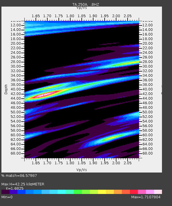
250A Grady, AL, USA - Earthquake Result Viewer
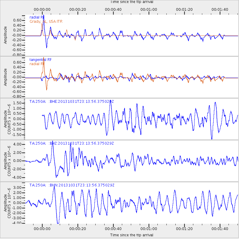
Earthquake location: Near Coast Of Central Chile
Earthquake latitude/longitude: -30.3/-71.5
Earthquake time(UTC): 2013/10/31 (304) 23:03:59 GMT
Earthquake Depth: 27 km
Earthquake Magnitude: 6.6 MWW, 6.4 MWB, 6.5 MWC, 6.6 MWW, 6.6 MI
Earthquake Catalog/Contributor: NEIC PDE/NEIC COMCAT
Network: TA USArray Transportable Network (new EarthScope stations)
Station: 250A Grady, AL, USA
Lat/Lon: 31.98 N/86.27 W
Elevation: 152 m
Distance: 63.5 deg
Az: 346.011 deg
Baz: 165.758 deg
Ray Param: 0.059504002
Estimated Moho Depth: 42.25 km
Estimated Crust Vp/Vs: 1.68
Assumed Crust Vp: 6.187 km/s
Estimated Crust Vs: 3.677 km/s
Estimated Crust Poisson's Ratio: 0.23
Radial Match: 86.57987 %
Radial Bump: 343
Transverse Match: 70.03298 %
Transverse Bump: 359
SOD ConfigId: 626651
Insert Time: 2014-04-19 09:08:44.038 +0000
GWidth: 2.5
Max Bumps: 400
Tol: 0.001

Signal To Noise

ChannelStoNSTALTA
TA:250A: :BHZ:20131031T23:13:56.375029Z4.6217387.0388927E-71.5229969E-7
TA:250A: :BHN:20131031T23:13:56.375029Z1.42326264.2314983E-72.9730975E-7
TA:250A: :BHE:20131031T23:13:56.375029Z0.83384473.7278502E-74.4706766E-7
Arrivals
Ps4.9 SECOND
PpPs18 SECOND
PsPs/PpSs22 SECOND