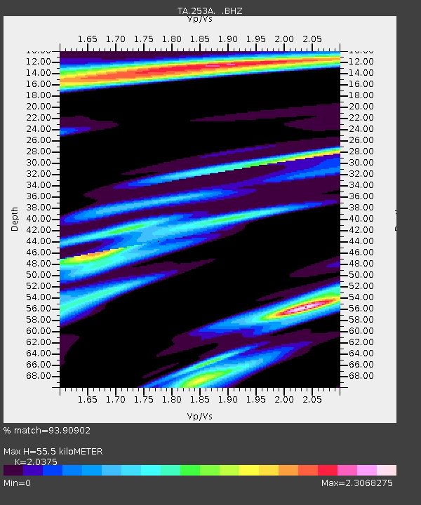
253A Americus, GA, USA - Earthquake Result Viewer
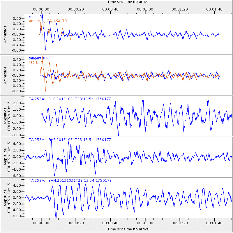
Earthquake location: Near Coast Of Central Chile
Earthquake latitude/longitude: -30.3/-71.5
Earthquake time(UTC): 2013/10/31 (304) 23:03:59 GMT
Earthquake Depth: 27 km
Earthquake Magnitude: 6.6 MWW, 6.4 MWB, 6.5 MWC, 6.6 MWW, 6.6 MI
Earthquake Catalog/Contributor: NEIC PDE/NEIC COMCAT
Network: TA USArray Transportable Network (new EarthScope stations)
Station: 253A Americus, GA, USA
Lat/Lon: 32.06 N/84.13 W
Elevation: 136 m
Distance: 63.2 deg
Az: 348.011 deg
Baz: 167.784 deg
Ray Param: 0.059720613
Estimated Moho Depth: 55.5 km
Estimated Crust Vp/Vs: 2.04
Assumed Crust Vp: 6.719 km/s
Estimated Crust Vs: 3.298 km/s
Estimated Crust Poisson's Ratio: 0.34
Radial Match: 93.90902 %
Radial Bump: 359
Transverse Match: 75.25394 %
Transverse Bump: 400
SOD ConfigId: 626651
Insert Time: 2014-04-19 09:08:46.819 +0000
GWidth: 2.5
Max Bumps: 400
Tol: 0.001

Signal To Noise

ChannelStoNSTALTA
TA:253A: :BHZ:20131031T23:13:54.175017Z3.341389.4473626E-72.8273837E-7
TA:253A: :BHN:20131031T23:13:54.175017Z0.71021354.149423E-75.842501E-7
TA:253A: :BHE:20131031T23:13:54.175017Z0.523449664.1804546E-77.986354E-7
Arrivals
Ps8.9 SECOND
PpPs24 SECOND
PsPs/PpSs33 SECOND