256A Glennville, GA, USA - Earthquake Result Viewer
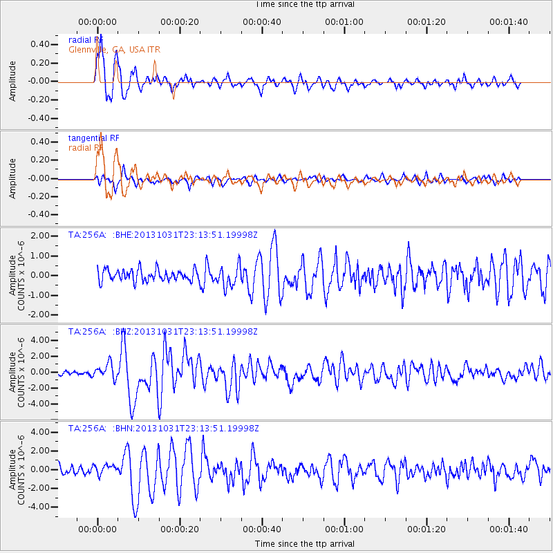
Earthquake location: Near Coast Of Central Chile
Earthquake latitude/longitude: -30.3/-71.5
Earthquake time(UTC): 2013/10/31 (304) 23:03:59 GMT
Earthquake Depth: 27 km
Earthquake Magnitude: 6.6 MWW, 6.4 MWB, 6.5 MWC, 6.6 MWW, 6.6 MI
Earthquake Catalog/Contributor: NEIC PDE/NEIC COMCAT
Network: TA USArray Transportable Network (new EarthScope stations)
Station: 256A Glennville, GA, USA
Lat/Lon: 31.98 N/81.89 W
Elevation: 46 m
Distance: 62.7 deg
Az: 350.092 deg
Baz: 169.914 deg
Ray Param: 0.06001037
Estimated Moho Depth: 13.0 km
Estimated Crust Vp/Vs: 1.64
Assumed Crust Vp: 5.989 km/s
Estimated Crust Vs: 3.652 km/s
Estimated Crust Poisson's Ratio: 0.20
Radial Match: 93.07309 %
Radial Bump: 400
Transverse Match: 70.24042 %
Transverse Bump: 393
SOD ConfigId: 626651
Insert Time: 2014-04-19 09:08:54.673 +0000
GWidth: 2.5
Max Bumps: 400
Tol: 0.001

Signal To Noise

ChannelStoNSTALTA
TA:256A: :BHZ:20131031T23:13:51.19998Z2.4273819.605508E-73.957149E-7
TA:256A: :BHN:20131031T23:13:51.19998Z1.13624455.3167554E-74.679235E-7
TA:256A: :BHE:20131031T23:13:51.19998Z1.86778965.410074E-72.8965115E-7
Arrivals
Ps1.4 SECOND
PpPs5.5 SECOND
PsPs/PpSs6.9 SECOND