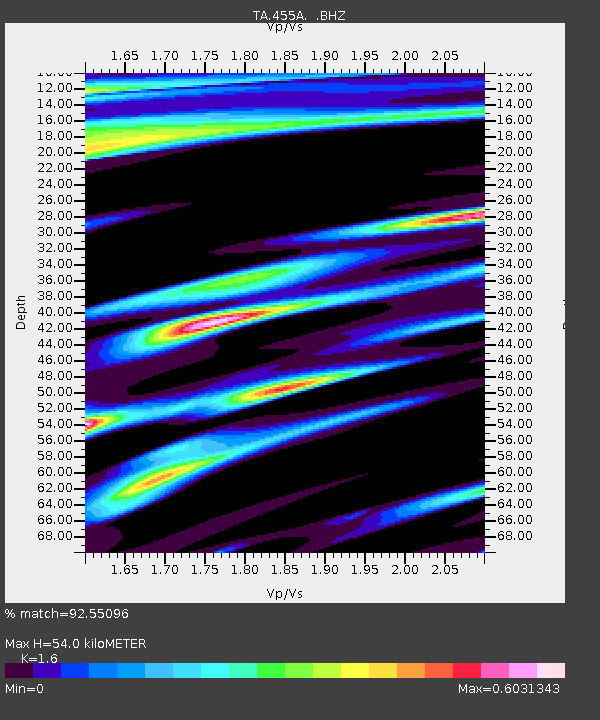
455A Stateville, GA, USA - Earthquake Result Viewer

Earthquake location: Near Coast Of Central Chile
Earthquake latitude/longitude: -30.3/-71.5
Earthquake time(UTC): 2013/10/31 (304) 23:03:59 GMT
Earthquake Depth: 27 km
Earthquake Magnitude: 6.6 MWW, 6.4 MWB, 6.5 MWC, 6.6 MWW, 6.6 MI
Earthquake Catalog/Contributor: NEIC PDE/NEIC COMCAT
Network: TA USArray Transportable Network (new EarthScope stations)
Station: 455A Stateville, GA, USA
Lat/Lon: 30.74 N/83.03 W
Elevation: 44 m
Distance: 61.7 deg
Az: 348.751 deg
Baz: 168.699 deg
Ray Param: 0.06068319
Estimated Moho Depth: 54.0 km
Estimated Crust Vp/Vs: 1.60
Assumed Crust Vp: 6.565 km/s
Estimated Crust Vs: 4.103 km/s
Estimated Crust Poisson's Ratio: 0.18
Radial Match: 92.55096 %
Radial Bump: 326
Transverse Match: 73.772064 %
Transverse Bump: 400
SOD ConfigId: 626651
Insert Time: 2014-04-19 09:09:14.720 +0000
GWidth: 2.5
Max Bumps: 400
Tol: 0.001

Signal To Noise

ChannelStoNSTALTA
TA:455A: :BHZ:20131031T23:13:44.300017Z2.79507141.1645823E-64.1665564E-7
TA:455A: :BHN:20131031T23:13:44.300017Z0.993039372.7424122E-72.7616346E-7
TA:455A: :BHE:20131031T23:13:44.300017Z1.07217814.1153604E-73.8383178E-7
Arrivals
Ps5.2 SECOND
PpPs20 SECOND
PsPs/PpSs25 SECOND