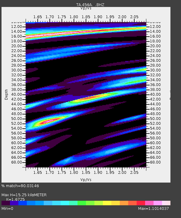
456A Hilliard, FL, USA - Earthquake Result Viewer
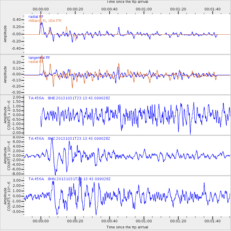
Earthquake location: Near Coast Of Central Chile
Earthquake latitude/longitude: -30.3/-71.5
Earthquake time(UTC): 2013/10/31 (304) 23:03:59 GMT
Earthquake Depth: 27 km
Earthquake Magnitude: 6.6 MWW, 6.4 MWB, 6.5 MWC, 6.6 MWW, 6.6 MI
Earthquake Catalog/Contributor: NEIC PDE/NEIC COMCAT
Network: TA USArray Transportable Network (new EarthScope stations)
Station: 456A Hilliard, FL, USA
Lat/Lon: 30.72 N/82.02 W
Elevation: 26 m
Distance: 61.5 deg
Az: 349.713 deg
Baz: 169.667 deg
Ray Param: 0.060796663
Estimated Moho Depth: 15.25 km
Estimated Crust Vp/Vs: 1.67
Assumed Crust Vp: 6.565 km/s
Estimated Crust Vs: 3.925 km/s
Estimated Crust Poisson's Ratio: 0.22
Radial Match: 90.03146 %
Radial Bump: 400
Transverse Match: 70.27505 %
Transverse Bump: 400
SOD ConfigId: 626651
Insert Time: 2014-04-19 09:09:16.101 +0000
GWidth: 2.5
Max Bumps: 400
Tol: 0.001

Signal To Noise

ChannelStoNSTALTA
TA:456A: :BHZ:20131031T23:13:43.099028Z2.58475181.1492226E-64.4461626E-7
TA:456A: :BHN:20131031T23:13:43.099028Z1.05463464.0680837E-73.8573395E-7
TA:456A: :BHE:20131031T23:13:43.099028Z1.07652124.9724395E-74.6189894E-7
Arrivals
Ps1.6 SECOND
PpPs5.9 SECOND
PsPs/PpSs7.5 SECOND