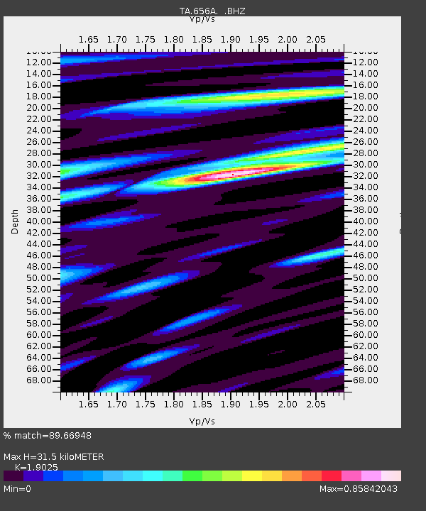
656A Willston, FL, USA - Earthquake Result Viewer

Earthquake location: Near Coast Of Central Chile
Earthquake latitude/longitude: -30.3/-71.5
Earthquake time(UTC): 2013/10/31 (304) 23:03:59 GMT
Earthquake Depth: 27 km
Earthquake Magnitude: 6.6 MWW, 6.4 MWB, 6.5 MWC, 6.6 MWW, 6.6 MI
Earthquake Catalog/Contributor: NEIC PDE/NEIC COMCAT
Network: TA USArray Transportable Network (new EarthScope stations)
Station: 656A Willston, FL, USA
Lat/Lon: 29.37 N/82.53 W
Elevation: 28 m
Distance: 60.3 deg
Az: 348.927 deg
Baz: 169.029 deg
Ray Param: 0.06161467
Estimated Moho Depth: 31.5 km
Estimated Crust Vp/Vs: 1.90
Assumed Crust Vp: 5.989 km/s
Estimated Crust Vs: 3.148 km/s
Estimated Crust Poisson's Ratio: 0.31
Radial Match: 89.66948 %
Radial Bump: 400
Transverse Match: 71.98591 %
Transverse Bump: 400
SOD ConfigId: 626651
Insert Time: 2014-04-19 09:09:25.445 +0000
GWidth: 2.5
Max Bumps: 400
Tol: 0.001

Signal To Noise

ChannelStoNSTALTA
TA:656A: :BHZ:20131031T23:13:34.649993Z3.37810429.977915E-72.9537028E-7
TA:656A: :BHN:20131031T23:13:34.649993Z2.01345095.219028E-72.5920812E-7
TA:656A: :BHE:20131031T23:13:34.649993Z0.88927893.254255E-73.6594312E-7
Arrivals
Ps4.9 SECOND
PpPs15 SECOND
PsPs/PpSs20 SECOND