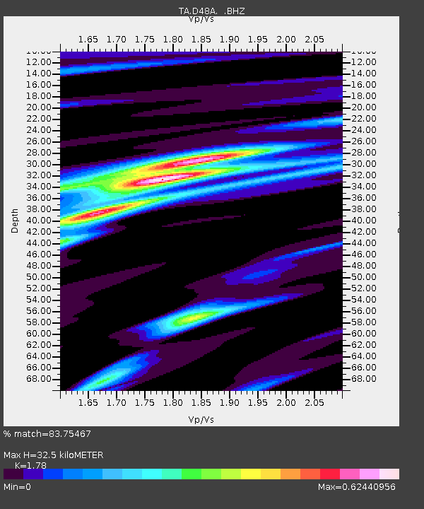
D48A Paudash Township, ON, CAN - Earthquake Result Viewer

Earthquake location: Near Coast Of Central Chile
Earthquake latitude/longitude: -30.3/-71.5
Earthquake time(UTC): 2013/10/31 (304) 23:03:59 GMT
Earthquake Depth: 27 km
Earthquake Magnitude: 6.6 MWW, 6.4 MWB, 6.5 MWC, 6.6 MWW, 6.6 MI
Earthquake Catalog/Contributor: NEIC PDE/NEIC COMCAT
Network: TA USArray Transportable Network (new EarthScope stations)
Station: D48A Paudash Township, ON, CAN
Lat/Lon: 47.17 N/81.81 W
Elevation: 434 m
Distance: 77.7 deg
Az: 352.837 deg
Baz: 170.904 deg
Ray Param: 0.050135184
Estimated Moho Depth: 32.5 km
Estimated Crust Vp/Vs: 1.78
Assumed Crust Vp: 6.467 km/s
Estimated Crust Vs: 3.633 km/s
Estimated Crust Poisson's Ratio: 0.27
Radial Match: 83.75467 %
Radial Bump: 302
Transverse Match: 73.69726 %
Transverse Bump: 304
SOD ConfigId: 626651
Insert Time: 2014-04-19 09:09:53.484 +0000
GWidth: 2.5
Max Bumps: 400
Tol: 0.001

Signal To Noise

ChannelStoNSTALTA
TA:D48A: :BHZ:20131031T23:15:22.524993Z2.13111477.6988374E-73.612587E-7
TA:D48A: :BHN:20131031T23:15:22.524993Z0.867580652.4768494E-72.8548925E-7
TA:D48A: :BHE:20131031T23:15:22.524993Z1.61118822.6112565E-71.6207025E-7
Arrivals
Ps4.0 SECOND
PpPs14 SECOND
PsPs/PpSs18 SECOND