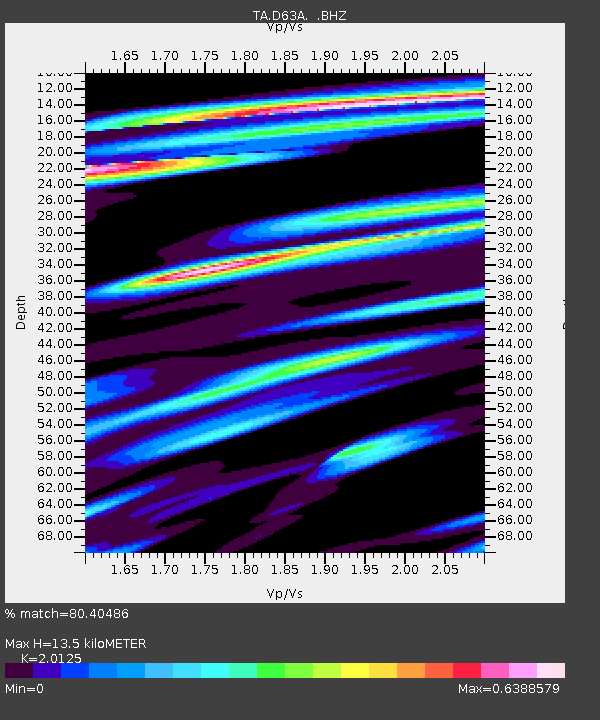
D63A Stockholm, ME, USA - Earthquake Result Viewer
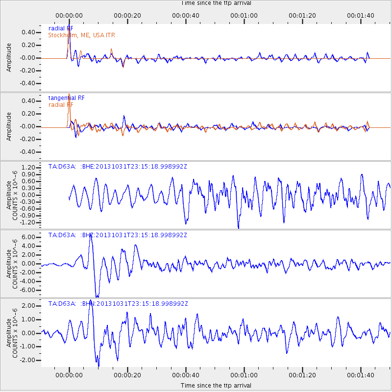
Earthquake location: Near Coast Of Central Chile
Earthquake latitude/longitude: -30.3/-71.5
Earthquake time(UTC): 2013/10/31 (304) 23:03:59 GMT
Earthquake Depth: 27 km
Earthquake Magnitude: 6.6 MWW, 6.4 MWB, 6.5 MWC, 6.6 MWW, 6.6 MI
Earthquake Catalog/Contributor: NEIC PDE/NEIC COMCAT
Network: TA USArray Transportable Network (new EarthScope stations)
Station: D63A Stockholm, ME, USA
Lat/Lon: 47.04 N/68.11 W
Elevation: 256 m
Distance: 77.0 deg
Az: 2.396 deg
Baz: 183.031 deg
Ray Param: 0.050562806
Estimated Moho Depth: 13.5 km
Estimated Crust Vp/Vs: 2.01
Assumed Crust Vp: 6.419 km/s
Estimated Crust Vs: 3.19 km/s
Estimated Crust Poisson's Ratio: 0.34
Radial Match: 80.40486 %
Radial Bump: 400
Transverse Match: 69.07885 %
Transverse Bump: 400
SOD ConfigId: 626651
Insert Time: 2014-04-19 09:10:23.434 +0000
GWidth: 2.5
Max Bumps: 400
Tol: 0.001

Signal To Noise

ChannelStoNSTALTA
TA:D63A: :BHZ:20131031T23:15:18.998992Z4.79643731.0472589E-62.1834101E-7
TA:D63A: :BHN:20131031T23:15:18.998992Z1.70689135.82909E-73.415033E-7
TA:D63A: :BHE:20131031T23:15:18.998992Z0.7425032.5090563E-73.379187E-7
Arrivals
Ps2.2 SECOND
PpPs6.2 SECOND
PsPs/PpSs8.4 SECOND