You are here: Home > Network List > TA - USArray Transportable Network (new EarthScope stations) Stations List
> Station E43A Lone Tree Farm, Eben Junction, MI, USA > Earthquake Result Viewer
E43A Lone Tree Farm, Eben Junction, MI, USA - Earthquake Result Viewer

| Earthquake location: |
Near Coast Of Central Chile |
| Earthquake latitude/longitude: |
-30.3/-71.5 |
| Earthquake time(UTC): |
2013/10/31 (304) 23:03:59 GMT |
| Earthquake Depth: |
27 km |
| Earthquake Magnitude: |
6.6 MWW, 6.4 MWB, 6.5 MWC, 6.6 MWW, 6.6 MI |
| Earthquake Catalog/Contributor: |
NEIC PDE/NEIC COMCAT |
|
| Network: |
TA USArray Transportable Network (new EarthScope stations) |
| Station: |
E43A Lone Tree Farm, Eben Junction, MI, USA |
| Lat/Lon: |
46.38 N/87.00 W |
| Elevation: |
303 m |
|
| Distance: |
77.6 deg |
| Az: |
349.097 deg |
| Baz: |
166.332 deg |
| Ray Param: |
0.050188866 |
| Estimated Moho Depth: |
39.75 km |
| Estimated Crust Vp/Vs: |
1.72 |
| Assumed Crust Vp: |
6.472 km/s |
| Estimated Crust Vs: |
3.768 km/s |
| Estimated Crust Poisson's Ratio: |
0.24 |
|
| Radial Match: |
89.70595 % |
| Radial Bump: |
310 |
| Transverse Match: |
83.856316 % |
| Transverse Bump: |
400 |
| SOD ConfigId: |
626651 |
| Insert Time: |
2014-04-19 09:10:29.209 +0000 |
| GWidth: |
2.5 |
| Max Bumps: |
400 |
| Tol: |
0.001 |
|
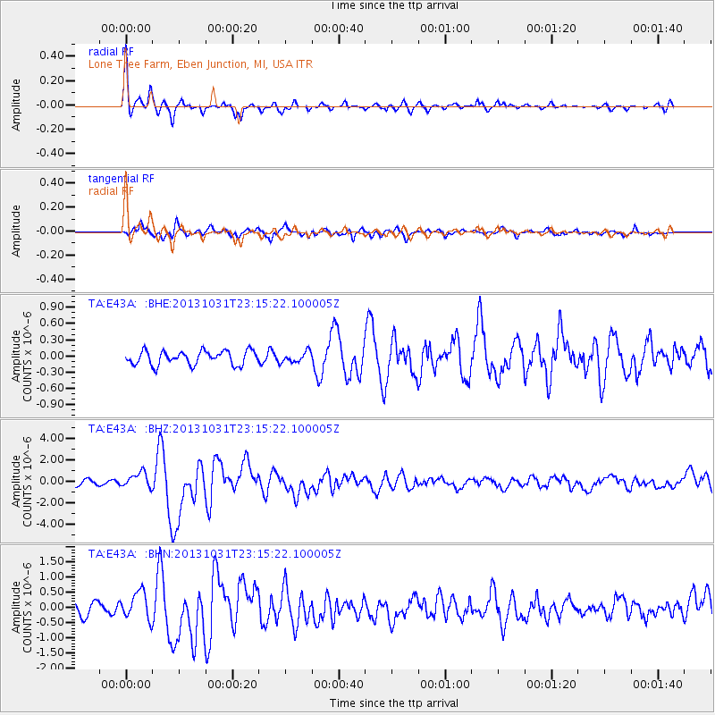
Signal To Noise
| Channel | StoN | STA | LTA |
| TA:E43A: :BHZ:20131031T23:15:22.100005Z | 4.1210628 | 7.195642E-7 | 1.7460647E-7 |
| TA:E43A: :BHN:20131031T23:15:22.100005Z | 2.524386 | 4.622971E-7 | 1.831325E-7 |
| TA:E43A: :BHE:20131031T23:15:22.100005Z | 0.7667891 | 9.7580184E-8 | 1.2725819E-7 |
| Arrivals |
| Ps | 4.5 SECOND |
| PpPs | 16 SECOND |
| PsPs/PpSs | 21 SECOND |


