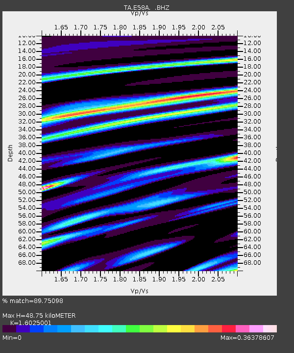
E58A La Victoria, QC, CAN - Earthquake Result Viewer
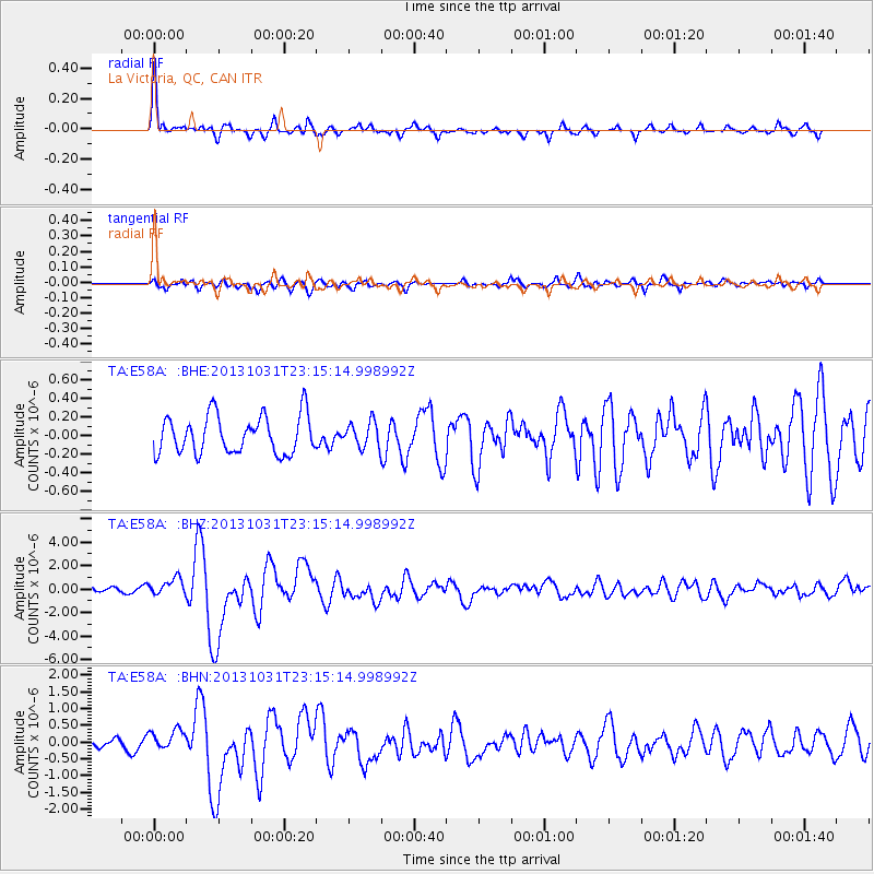
Earthquake location: Near Coast Of Central Chile
Earthquake latitude/longitude: -30.3/-71.5
Earthquake time(UTC): 2013/10/31 (304) 23:03:59 GMT
Earthquake Depth: 27 km
Earthquake Magnitude: 6.6 MWW, 6.4 MWB, 6.5 MWC, 6.6 MWW, 6.6 MI
Earthquake Catalog/Contributor: NEIC PDE/NEIC COMCAT
Network: TA USArray Transportable Network (new EarthScope stations)
Station: E58A La Victoria, QC, CAN
Lat/Lon: 46.37 N/73.28 W
Elevation: 233 m
Distance: 76.3 deg
Az: 358.749 deg
Baz: 178.437 deg
Ray Param: 0.051038906
Estimated Moho Depth: 48.75 km
Estimated Crust Vp/Vs: 1.60
Assumed Crust Vp: 6.61 km/s
Estimated Crust Vs: 4.125 km/s
Estimated Crust Poisson's Ratio: 0.18
Radial Match: 89.75098 %
Radial Bump: 400
Transverse Match: 71.64418 %
Transverse Bump: 400
SOD ConfigId: 626651
Insert Time: 2014-04-19 09:10:53.526 +0000
GWidth: 2.5
Max Bumps: 400
Tol: 0.001

Signal To Noise

ChannelStoNSTALTA
TA:E58A: :BHZ:20131031T23:15:14.998992Z3.54516867.175203E-72.0239385E-7
TA:E58A: :BHN:20131031T23:15:14.998992Z1.55439292.922872E-71.8803946E-7
TA:E58A: :BHE:20131031T23:15:14.998992Z0.663116341.3444709E-72.0275039E-7
Arrivals
Ps4.6 SECOND
PpPs18 SECOND
PsPs/PpSs23 SECOND