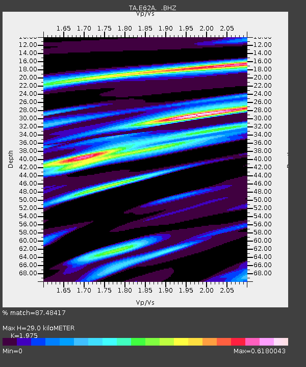
E62A Clayton Lake, ME, USA - Earthquake Result Viewer
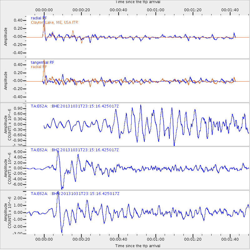
Earthquake location: Near Coast Of Central Chile
Earthquake latitude/longitude: -30.3/-71.5
Earthquake time(UTC): 2013/10/31 (304) 23:03:59 GMT
Earthquake Depth: 27 km
Earthquake Magnitude: 6.6 MWW, 6.4 MWB, 6.5 MWC, 6.6 MWW, 6.6 MI
Earthquake Catalog/Contributor: NEIC PDE/NEIC COMCAT
Network: TA USArray Transportable Network (new EarthScope stations)
Station: E62A Clayton Lake, ME, USA
Lat/Lon: 46.62 N/69.52 W
Elevation: 356 m
Distance: 76.6 deg
Az: 1.416 deg
Baz: 181.777 deg
Ray Param: 0.050869163
Estimated Moho Depth: 29.0 km
Estimated Crust Vp/Vs: 1.98
Assumed Crust Vp: 6.419 km/s
Estimated Crust Vs: 3.25 km/s
Estimated Crust Poisson's Ratio: 0.33
Radial Match: 87.48417 %
Radial Bump: 400
Transverse Match: 86.40025 %
Transverse Bump: 400
SOD ConfigId: 626651
Insert Time: 2014-04-19 09:11:00.630 +0000
GWidth: 2.5
Max Bumps: 400
Tol: 0.001

Signal To Noise

ChannelStoNSTALTA
TA:E62A: :BHZ:20131031T23:15:16.425017Z2.0539756.3160286E-73.075027E-7
TA:E62A: :BHN:20131031T23:15:16.425017Z1.39492743.3593236E-72.4082425E-7
TA:E62A: :BHE:20131031T23:15:16.425017Z1.42092862.3665939E-71.6655262E-7
Arrivals
Ps4.5 SECOND
PpPs13 SECOND
PsPs/PpSs18 SECOND