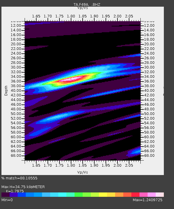
F49A Sandfield, ON, CAN - Earthquake Result Viewer
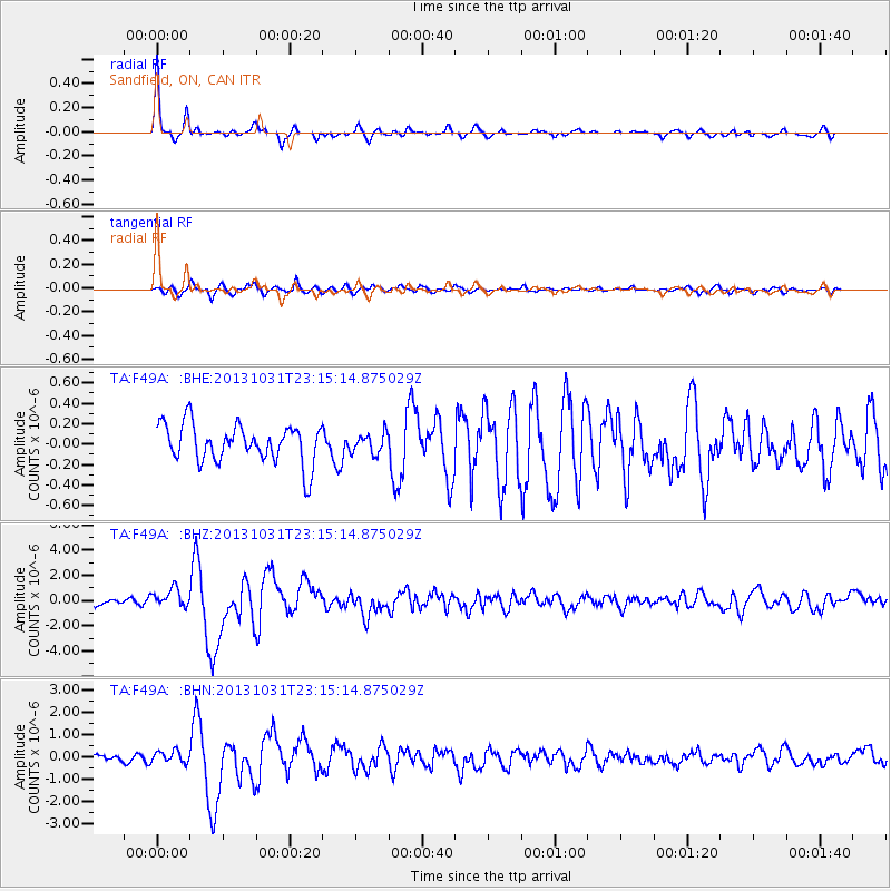
Earthquake location: Near Coast Of Central Chile
Earthquake latitude/longitude: -30.3/-71.5
Earthquake time(UTC): 2013/10/31 (304) 23:03:59 GMT
Earthquake Depth: 27 km
Earthquake Magnitude: 6.6 MWW, 6.4 MWB, 6.5 MWC, 6.6 MWW, 6.6 MI
Earthquake Catalog/Contributor: NEIC PDE/NEIC COMCAT
Network: TA USArray Transportable Network (new EarthScope stations)
Station: F49A Sandfield, ON, CAN
Lat/Lon: 45.76 N/82.04 W
Elevation: 230 m
Distance: 76.3 deg
Az: 352.44 deg
Baz: 170.645 deg
Ray Param: 0.051055714
Estimated Moho Depth: 34.75 km
Estimated Crust Vp/Vs: 1.80
Assumed Crust Vp: 6.483 km/s
Estimated Crust Vs: 3.606 km/s
Estimated Crust Poisson's Ratio: 0.28
Radial Match: 88.18555 %
Radial Bump: 324
Transverse Match: 73.59678 %
Transverse Bump: 400
SOD ConfigId: 626651
Insert Time: 2014-04-19 09:11:19.849 +0000
GWidth: 2.5
Max Bumps: 400
Tol: 0.001

Signal To Noise

ChannelStoNSTALTA
TA:F49A: :BHZ:20131031T23:15:14.875029Z2.31175957.2618235E-73.141254E-7
TA:F49A: :BHN:20131031T23:15:14.875029Z1.64115452.5786102E-71.5712172E-7
TA:F49A: :BHE:20131031T23:15:14.875029Z0.52850939.957196E-81.8840153E-7
Arrivals
Ps4.4 SECOND
PpPs15 SECOND
PsPs/PpSs19 SECOND