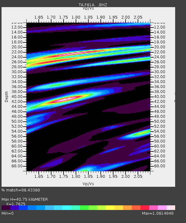
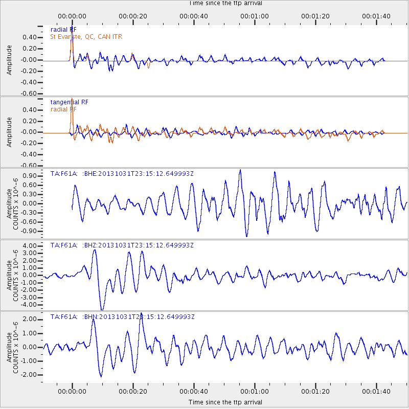
F61A St Evariste, QC, CAN - Earthquake Result Viewer

Earthquake location: Near Coast Of Central Chile
Earthquake latitude/longitude: -30.3/-71.5
Earthquake time(UTC): 2013/10/31 (304) 23:03:59 GMT
Earthquake Depth: 27 km
Earthquake Magnitude: 6.6 MWW, 6.4 MWB, 6.5 MWC, 6.6 MWW, 6.6 MI
Earthquake Catalog/Contributor: NEIC PDE/NEIC COMCAT
Network: TA USArray Transportable Network (new EarthScope stations)
Station: F61A St Evariste, QC, CAN
Lat/Lon: 45.97 N/70.99 W
Elevation: 350 m
Distance: 75.9 deg
Az: 0.381 deg
Baz: 180.472 deg
Ray Param: 0.05131708
Estimated Moho Depth: 40.75 km
Estimated Crust Vp/Vs: 1.76
Assumed Crust Vp: 6.419 km/s
Estimated Crust Vs: 3.642 km/s
Estimated Crust Poisson's Ratio: 0.26
Radial Match: 86.43368 %
Radial Bump: 400
Transverse Match: 80.38519 %
Transverse Bump: 400
SOD ConfigId: 626651
Insert Time: 2014-04-19 09:11:34.663 +0000
GWidth: 2.5
Max Bumps: 400
Tol: 0.001

Signal To Noise

ChannelStoNSTALTA
TA:F61A: :BHZ:20131031T23:15:12.649993Z1.89684036.8011093E-73.5854939E-7
TA:F61A: :BHN:20131031T23:15:12.649993Z1.22717133.0667545E-72.4990436E-7
TA:F61A: :BHE:20131031T23:15:12.649993Z1.64695113.4247208E-72.0794307E-7
Arrivals
Ps5.0 SECOND
PpPs17 SECOND
PsPs/PpSs22 SECOND