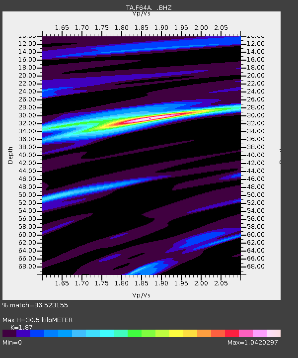
F64A Sherman, ME, USA - Earthquake Result Viewer

Earthquake location: Near Coast Of Central Chile
Earthquake latitude/longitude: -30.3/-71.5
Earthquake time(UTC): 2013/10/31 (304) 23:03:59 GMT
Earthquake Depth: 27 km
Earthquake Magnitude: 6.6 MWW, 6.4 MWB, 6.5 MWC, 6.6 MWW, 6.6 MI
Earthquake Catalog/Contributor: NEIC PDE/NEIC COMCAT
Network: TA USArray Transportable Network (new EarthScope stations)
Station: F64A Sherman, ME, USA
Lat/Lon: 45.86 N/68.35 W
Elevation: 179 m
Distance: 75.9 deg
Az: 2.285 deg
Baz: 182.829 deg
Ray Param: 0.051356137
Estimated Moho Depth: 30.5 km
Estimated Crust Vp/Vs: 1.87
Assumed Crust Vp: 6.419 km/s
Estimated Crust Vs: 3.433 km/s
Estimated Crust Poisson's Ratio: 0.30
Radial Match: 86.523155 %
Radial Bump: 338
Transverse Match: 77.39411 %
Transverse Bump: 400
SOD ConfigId: 626651
Insert Time: 2014-04-19 09:11:43.236 +0000
GWidth: 2.5
Max Bumps: 400
Tol: 0.001

Signal To Noise

ChannelStoNSTALTA
TA:F64A: :BHZ:20131031T23:15:12.324004Z3.33790377.4920257E-72.2445302E-7
TA:F64A: :BHN:20131031T23:15:12.324004Z1.99258034.481426E-72.2490568E-7
TA:F64A: :BHE:20131031T23:15:12.324004Z1.32578922.9179245E-72.2008962E-7
Arrivals
Ps4.3 SECOND
PpPs13 SECOND
PsPs/PpSs17 SECOND