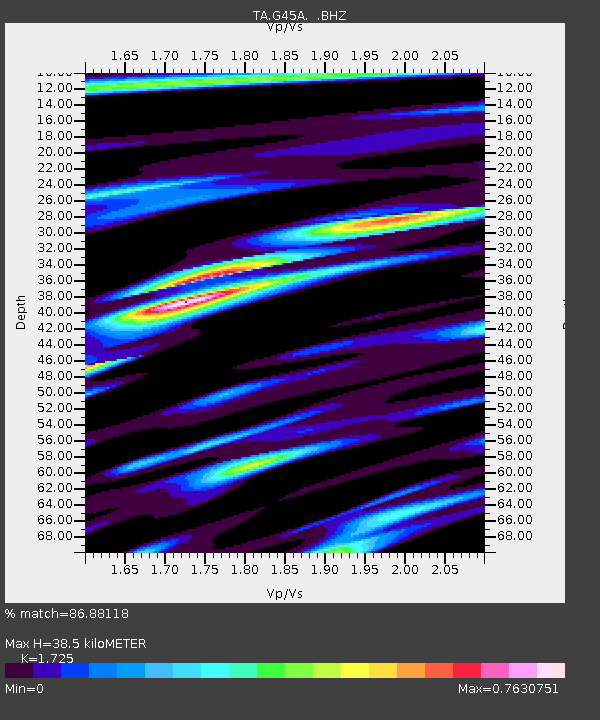
G45A Suttons Bay, MI, USA - Earthquake Result Viewer
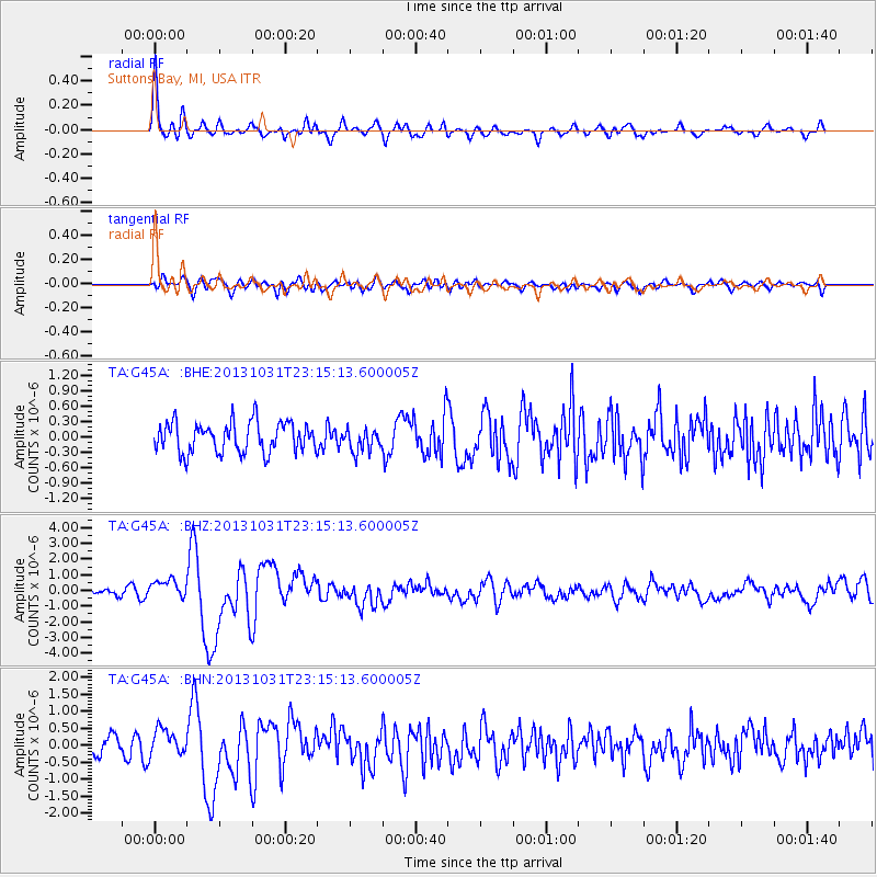
Earthquake location: Near Coast Of Central Chile
Earthquake latitude/longitude: -30.3/-71.5
Earthquake time(UTC): 2013/10/31 (304) 23:03:59 GMT
Earthquake Depth: 27 km
Earthquake Magnitude: 6.6 MWW, 6.4 MWB, 6.5 MWC, 6.6 MWW, 6.6 MI
Earthquake Catalog/Contributor: NEIC PDE/NEIC COMCAT
Network: TA USArray Transportable Network (new EarthScope stations)
Station: G45A Suttons Bay, MI, USA
Lat/Lon: 45.04 N/85.66 W
Elevation: 284 m
Distance: 76.1 deg
Az: 349.724 deg
Baz: 167.43 deg
Ray Param: 0.0512068
Estimated Moho Depth: 38.5 km
Estimated Crust Vp/Vs: 1.73
Assumed Crust Vp: 6.483 km/s
Estimated Crust Vs: 3.758 km/s
Estimated Crust Poisson's Ratio: 0.25
Radial Match: 86.88118 %
Radial Bump: 400
Transverse Match: 65.91829 %
Transverse Bump: 400
SOD ConfigId: 626651
Insert Time: 2014-04-19 09:11:55.890 +0000
GWidth: 2.5
Max Bumps: 400
Tol: 0.001

Signal To Noise

ChannelStoNSTALTA
TA:G45A: :BHZ:20131031T23:15:13.600005Z3.08010056.087634E-71.97644E-7
TA:G45A: :BHN:20131031T23:15:13.600005Z1.78465373.884125E-72.1764028E-7
TA:G45A: :BHE:20131031T23:15:13.600005Z0.75008032.2063317E-72.9414608E-7
Arrivals
Ps4.5 SECOND
PpPs16 SECOND
PsPs/PpSs20 SECOND