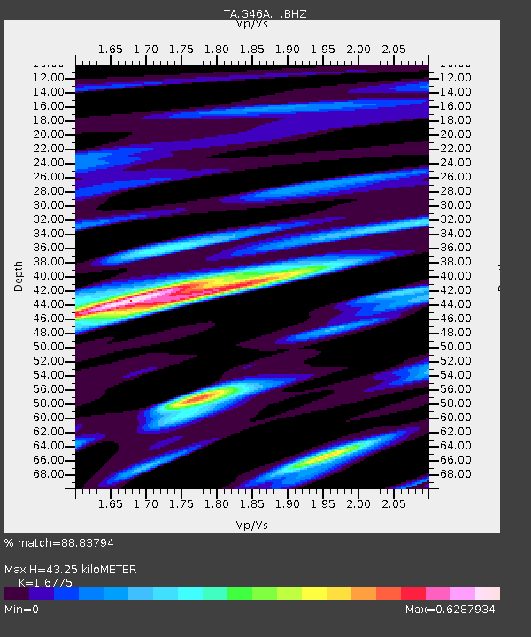
G46A Petoskey, MI, USA - Earthquake Result Viewer

Earthquake location: Near Coast Of Central Chile
Earthquake latitude/longitude: -30.3/-71.5
Earthquake time(UTC): 2013/10/31 (304) 23:03:59 GMT
Earthquake Depth: 27 km
Earthquake Magnitude: 6.6 MWW, 6.4 MWB, 6.5 MWC, 6.6 MWW, 6.6 MI
Earthquake Catalog/Contributor: NEIC PDE/NEIC COMCAT
Network: TA USArray Transportable Network (new EarthScope stations)
Station: G46A Petoskey, MI, USA
Lat/Lon: 45.32 N/84.86 W
Elevation: 239 m
Distance: 76.2 deg
Az: 350.35 deg
Baz: 168.142 deg
Ray Param: 0.0511045
Estimated Moho Depth: 43.25 km
Estimated Crust Vp/Vs: 1.68
Assumed Crust Vp: 6.483 km/s
Estimated Crust Vs: 3.864 km/s
Estimated Crust Poisson's Ratio: 0.22
Radial Match: 88.83794 %
Radial Bump: 400
Transverse Match: 74.924286 %
Transverse Bump: 400
SOD ConfigId: 626651
Insert Time: 2014-04-19 09:11:56.245 +0000
GWidth: 2.5
Max Bumps: 400
Tol: 0.001

Signal To Noise

ChannelStoNSTALTA
TA:G46A: :BHZ:20131031T23:15:14.44998Z3.5904457.957427E-72.2162787E-7
TA:G46A: :BHN:20131031T23:15:14.44998Z1.59353593.1721217E-71.9906182E-7
TA:G46A: :BHE:20131031T23:15:14.44998Z1.11990032.9610555E-72.644035E-7
Arrivals
Ps4.7 SECOND
PpPs17 SECOND
PsPs/PpSs22 SECOND