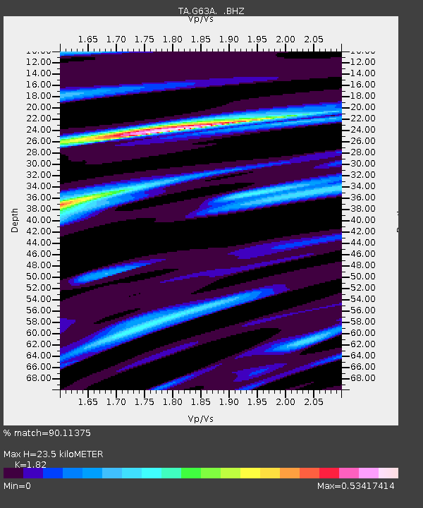
G63A Kingsbury, ME, USA - Earthquake Result Viewer

Earthquake location: Near Coast Of Central Chile
Earthquake latitude/longitude: -30.3/-71.5
Earthquake time(UTC): 2013/10/31 (304) 23:03:59 GMT
Earthquake Depth: 27 km
Earthquake Magnitude: 6.6 MWW, 6.4 MWB, 6.5 MWC, 6.6 MWW, 6.6 MI
Earthquake Catalog/Contributor: NEIC PDE/NEIC COMCAT
Network: TA USArray Transportable Network (new EarthScope stations)
Station: G63A Kingsbury, ME, USA
Lat/Lon: 45.11 N/69.62 W
Elevation: 363 m
Distance: 75.1 deg
Az: 1.394 deg
Baz: 181.703 deg
Ray Param: 0.051880423
Estimated Moho Depth: 23.5 km
Estimated Crust Vp/Vs: 1.82
Assumed Crust Vp: 6.419 km/s
Estimated Crust Vs: 3.527 km/s
Estimated Crust Poisson's Ratio: 0.28
Radial Match: 90.11375 %
Radial Bump: 354
Transverse Match: 73.09869 %
Transverse Bump: 400
SOD ConfigId: 626651
Insert Time: 2014-04-19 09:12:23.251 +0000
GWidth: 2.5
Max Bumps: 400
Tol: 0.001

Signal To Noise

ChannelStoNSTALTA
TA:G63A: :BHZ:20131031T23:15:07.850005Z2.99665459.2540336E-73.0881216E-7
TA:G63A: :BHN:20131031T23:15:07.850005Z2.0813963.874972E-71.8617179E-7
TA:G63A: :BHE:20131031T23:15:07.850005Z0.454699581.3936562E-73.0650045E-7
Arrivals
Ps3.1 SECOND
PpPs10 SECOND
PsPs/PpSs13 SECOND