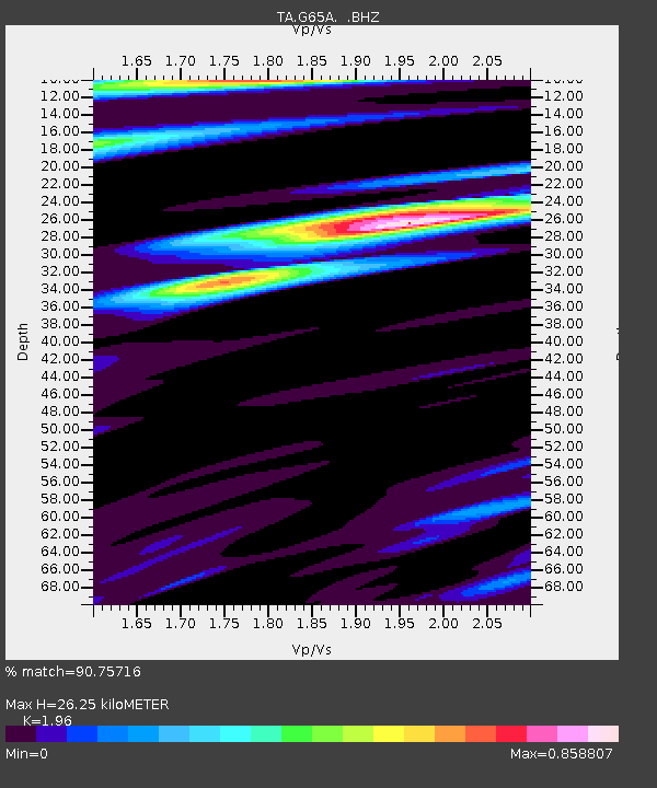
G65A Princeton, ME, USA - Earthquake Result Viewer
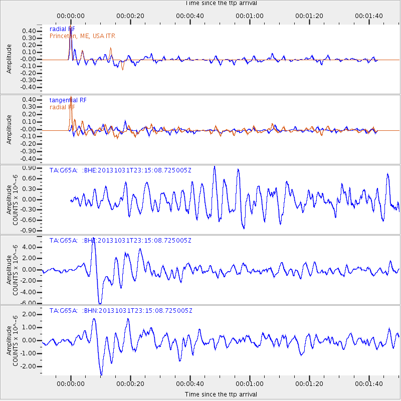
Earthquake location: Near Coast Of Central Chile
Earthquake latitude/longitude: -30.3/-71.5
Earthquake time(UTC): 2013/10/31 (304) 23:03:59 GMT
Earthquake Depth: 27 km
Earthquake Magnitude: 6.6 MWW, 6.4 MWB, 6.5 MWC, 6.6 MWW, 6.6 MI
Earthquake Catalog/Contributor: NEIC PDE/NEIC COMCAT
Network: TA USArray Transportable Network (new EarthScope stations)
Station: G65A Princeton, ME, USA
Lat/Lon: 45.20 N/67.56 W
Elevation: 78 m
Distance: 75.2 deg
Az: 2.893 deg
Baz: 183.54 deg
Ray Param: 0.051782303
Estimated Moho Depth: 26.25 km
Estimated Crust Vp/Vs: 1.96
Assumed Crust Vp: 6.419 km/s
Estimated Crust Vs: 3.275 km/s
Estimated Crust Poisson's Ratio: 0.32
Radial Match: 90.75716 %
Radial Bump: 358
Transverse Match: 78.40617 %
Transverse Bump: 400
SOD ConfigId: 626651
Insert Time: 2014-04-19 09:12:28.002 +0000
GWidth: 2.5
Max Bumps: 400
Tol: 0.001

Signal To Noise

ChannelStoNSTALTA
TA:G65A: :BHZ:20131031T23:15:08.725005Z2.7809186.477757E-72.3293592E-7
TA:G65A: :BHN:20131031T23:15:08.725005Z2.2166653.5921283E-71.6205102E-7
TA:G65A: :BHE:20131031T23:15:08.725005Z0.97175431.9179039E-71.973651E-7
Arrivals
Ps4.0 SECOND
PpPs12 SECOND
PsPs/PpSs16 SECOND