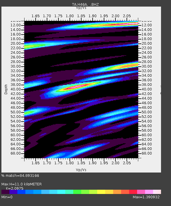
H46A Fife Lake, MI, USA - Earthquake Result Viewer
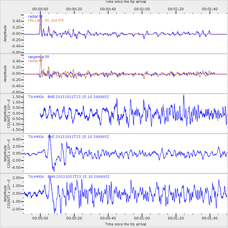
Earthquake location: Near Coast Of Central Chile
Earthquake latitude/longitude: -30.3/-71.5
Earthquake time(UTC): 2013/10/31 (304) 23:03:59 GMT
Earthquake Depth: 27 km
Earthquake Magnitude: 6.6 MWW, 6.4 MWB, 6.5 MWC, 6.6 MWW, 6.6 MI
Earthquake Catalog/Contributor: NEIC PDE/NEIC COMCAT
Network: TA USArray Transportable Network (new EarthScope stations)
Station: H46A Fife Lake, MI, USA
Lat/Lon: 44.54 N/85.20 W
Elevation: 329 m
Distance: 75.5 deg
Az: 349.939 deg
Baz: 167.801 deg
Ray Param: 0.0515839
Estimated Moho Depth: 11.0 km
Estimated Crust Vp/Vs: 2.10
Assumed Crust Vp: 6.483 km/s
Estimated Crust Vs: 3.091 km/s
Estimated Crust Poisson's Ratio: 0.35
Radial Match: 84.893166 %
Radial Bump: 400
Transverse Match: 67.28429 %
Transverse Bump: 400
SOD ConfigId: 626651
Insert Time: 2014-04-19 09:12:41.707 +0000
GWidth: 2.5
Max Bumps: 400
Tol: 0.001

Signal To Noise

ChannelStoNSTALTA
TA:H46A: :BHZ:20131031T23:15:10.399993Z3.25679618.194965E-72.516266E-7
TA:H46A: :BHN:20131031T23:15:10.399993Z1.69063844.540793E-72.6858453E-7
TA:H46A: :BHE:20131031T23:15:10.399993Z0.76129742.4912163E-73.2723298E-7
Arrivals
Ps1.9 SECOND
PpPs5.1 SECOND
PsPs/PpSs7.0 SECOND