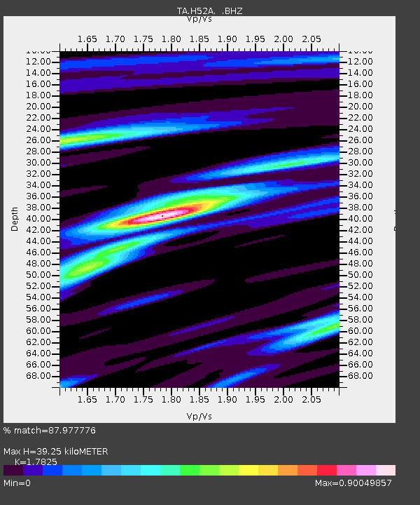
H52A Wyevale, ON, CAN - Earthquake Result Viewer
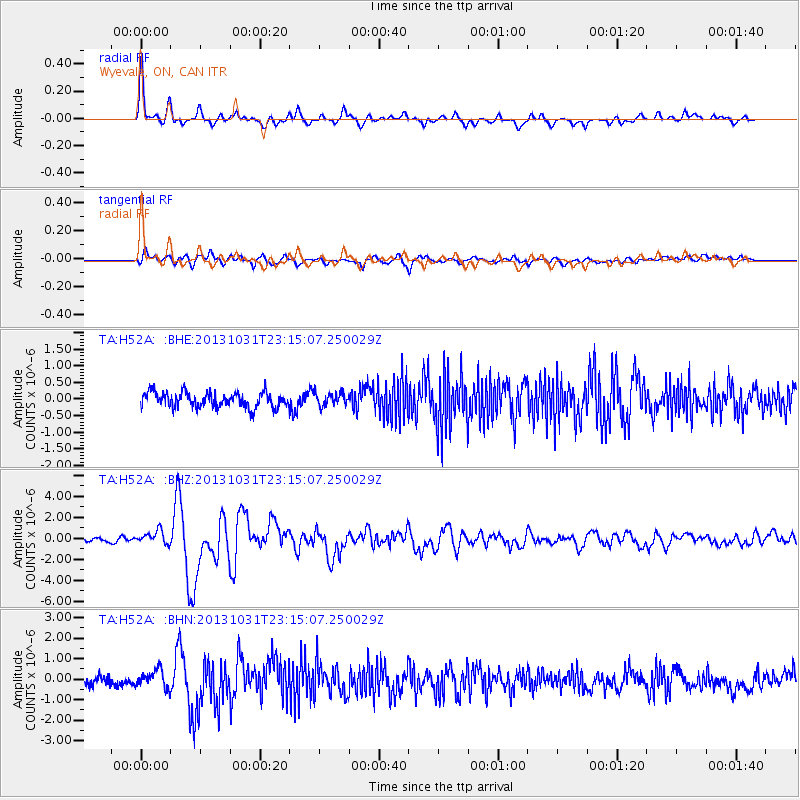
Earthquake location: Near Coast Of Central Chile
Earthquake latitude/longitude: -30.3/-71.5
Earthquake time(UTC): 2013/10/31 (304) 23:03:59 GMT
Earthquake Depth: 27 km
Earthquake Magnitude: 6.6 MWW, 6.4 MWB, 6.5 MWC, 6.6 MWW, 6.6 MI
Earthquake Catalog/Contributor: NEIC PDE/NEIC COMCAT
Network: TA USArray Transportable Network (new EarthScope stations)
Station: H52A Wyevale, ON, CAN
Lat/Lon: 44.64 N/79.89 W
Elevation: 209 m
Distance: 75.0 deg
Az: 353.825 deg
Baz: 172.512 deg
Ray Param: 0.051946443
Estimated Moho Depth: 39.25 km
Estimated Crust Vp/Vs: 1.78
Assumed Crust Vp: 6.577 km/s
Estimated Crust Vs: 3.69 km/s
Estimated Crust Poisson's Ratio: 0.27
Radial Match: 87.977776 %
Radial Bump: 400
Transverse Match: 72.13474 %
Transverse Bump: 400
SOD ConfigId: 626651
Insert Time: 2014-04-19 09:12:46.207 +0000
GWidth: 2.5
Max Bumps: 400
Tol: 0.001

Signal To Noise

ChannelStoNSTALTA
TA:H52A: :BHZ:20131031T23:15:07.250029Z2.94511156.449652E-72.1899517E-7
TA:H52A: :BHN:20131031T23:15:07.250029Z1.7600464.368856E-72.4822396E-7
TA:H52A: :BHE:20131031T23:15:07.250029Z0.858267551.9483362E-72.2700803E-7
Arrivals
Ps4.8 SECOND
PpPs16 SECOND
PsPs/PpSs21 SECOND