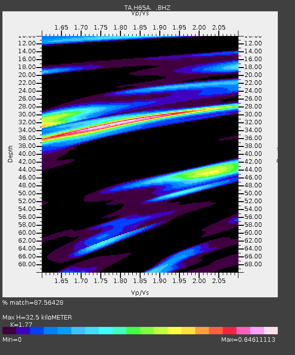
H65A Eastbrook, ME, USA - Earthquake Result Viewer

Earthquake location: Near Coast Of Central Chile
Earthquake latitude/longitude: -30.3/-71.5
Earthquake time(UTC): 2013/10/31 (304) 23:03:59 GMT
Earthquake Depth: 27 km
Earthquake Magnitude: 6.6 MWW, 6.4 MWB, 6.5 MWC, 6.6 MWW, 6.6 MI
Earthquake Catalog/Contributor: NEIC PDE/NEIC COMCAT
Network: TA USArray Transportable Network (new EarthScope stations)
Station: H65A Eastbrook, ME, USA
Lat/Lon: 44.70 N/68.25 W
Elevation: 98 m
Distance: 74.7 deg
Az: 2.421 deg
Baz: 182.936 deg
Ray Param: 0.052130587
Estimated Moho Depth: 32.5 km
Estimated Crust Vp/Vs: 1.77
Assumed Crust Vp: 6.419 km/s
Estimated Crust Vs: 3.627 km/s
Estimated Crust Poisson's Ratio: 0.27
Radial Match: 87.56428 %
Radial Bump: 400
Transverse Match: 74.59219 %
Transverse Bump: 400
SOD ConfigId: 626651
Insert Time: 2014-04-19 09:13:12.021 +0000
GWidth: 2.5
Max Bumps: 400
Tol: 0.001

Signal To Noise

ChannelStoNSTALTA
TA:H65A: :BHZ:20131031T23:15:05.675017Z3.97138297.565301E-71.9049538E-7
TA:H65A: :BHN:20131031T23:15:05.675017Z2.48756274.4355536E-71.7830922E-7
TA:H65A: :BHE:20131031T23:15:05.675017Z0.868615752.2828662E-72.6281657E-7
Arrivals
Ps4.0 SECOND
PpPs14 SECOND
PsPs/PpSs18 SECOND