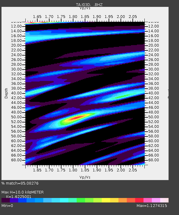
I03D Drain, OR, USA - Earthquake Result Viewer

Earthquake location: Near Coast Of Central Chile
Earthquake latitude/longitude: -30.3/-71.5
Earthquake time(UTC): 2013/10/31 (304) 23:03:59 GMT
Earthquake Depth: 27 km
Earthquake Magnitude: 6.6 MWW, 6.4 MWB, 6.5 MWC, 6.6 MWW, 6.6 MI
Earthquake Catalog/Contributor: NEIC PDE/NEIC COMCAT
Network: TA USArray Transportable Network (new EarthScope stations)
Station: I03D Drain, OR, USA
Lat/Lon: 43.70 N/123.35 W
Elevation: 140 m
Distance: 87.6 deg
Az: 325.2 deg
Baz: 137.111 deg
Ray Param: 0.04319294
Estimated Moho Depth: 10.0 km
Estimated Crust Vp/Vs: 1.62
Assumed Crust Vp: 6.522 km/s
Estimated Crust Vs: 4.019 km/s
Estimated Crust Poisson's Ratio: 0.19
Radial Match: 85.08276 %
Radial Bump: 400
Transverse Match: 79.39471 %
Transverse Bump: 400
SOD ConfigId: 626651
Insert Time: 2014-04-19 09:13:19.990 +0000
GWidth: 2.5
Max Bumps: 400
Tol: 0.001

Signal To Noise

ChannelStoNSTALTA
TA:I03D: :BHZ:20131031T23:16:13.899993Z2.52621033.9698003E-71.5714448E-7
TA:I03D: :BHN:20131031T23:16:13.899993Z1.52681292.7320326E-71.7893696E-7
TA:I03D: :BHE:20131031T23:16:13.899993Z1.74999441.6046603E-79.169516E-8
Arrivals
Ps1.0 SECOND
PpPs3.9 SECOND
PsPs/PpSs4.9 SECOND