You are here: Home > Network List > TA - USArray Transportable Network (new EarthScope stations) Stations List
> Station I45A Fountain, MI, USA > Earthquake Result Viewer
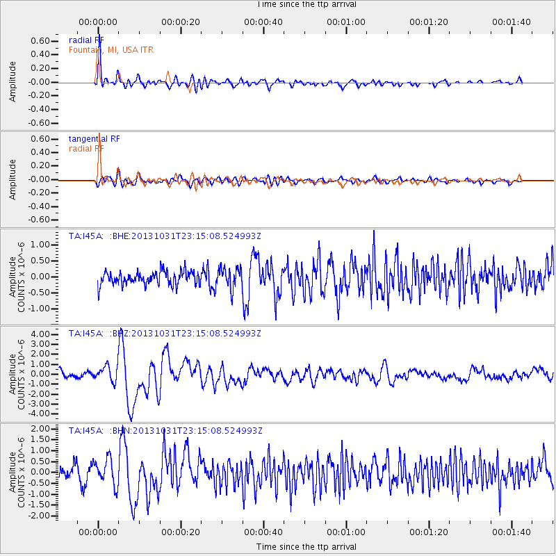
I45A Fountain, MI, USA - Earthquake Result Viewer
*The percent match for this event was below the threshold and hence no stack was calculated.
| Earthquake location: |
Near Coast Of Central Chile |
| Earthquake latitude/longitude: |
-30.3/-71.5 |
| Earthquake time(UTC): |
2013/10/31 (304) 23:03:59 GMT |
| Earthquake Depth: |
27 km |
| Earthquake Magnitude: |
6.6 MWW, 6.4 MWB, 6.5 MWC, 6.6 MWW, 6.6 MI |
| Earthquake Catalog/Contributor: |
NEIC PDE/NEIC COMCAT |
|
| Network: |
TA USArray Transportable Network (new EarthScope stations) |
| Station: |
I45A Fountain, MI, USA |
| Lat/Lon: |
44.04 N/86.23 W |
| Elevation: |
215 m |
|
| Distance: |
75.2 deg |
| Az: |
349.078 deg |
| Baz: |
166.866 deg |
| Ray Param: |
$rayparam |
*The percent match for this event was below the threshold and hence was not used in the summary stack. |
|
| Radial Match: |
77.57375 % |
| Radial Bump: |
400 |
| Transverse Match: |
65.49608 % |
| Transverse Bump: |
400 |
| SOD ConfigId: |
626651 |
| Insert Time: |
2014-04-19 09:13:29.193 +0000 |
| GWidth: |
2.5 |
| Max Bumps: |
400 |
| Tol: |
0.001 |
|
Signal To Noise
| Channel | StoN | STA | LTA |
| TA:I45A: :BHZ:20131031T23:15:08.524993Z | 2.4479764 | 8.17404E-7 | 3.3391007E-7 |
| TA:I45A: :BHN:20131031T23:15:08.524993Z | 1.693343 | 6.0324044E-7 | 3.562423E-7 |
| TA:I45A: :BHE:20131031T23:15:08.524993Z | 1.5859916 | 3.286563E-7 | 2.0722449E-7 |
| Arrivals |
| Ps | |
| PpPs | |
| PsPs/PpSs | |


