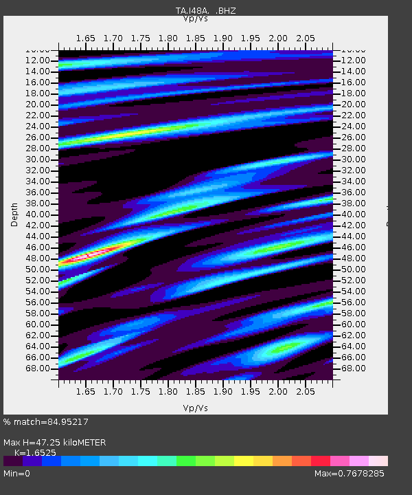
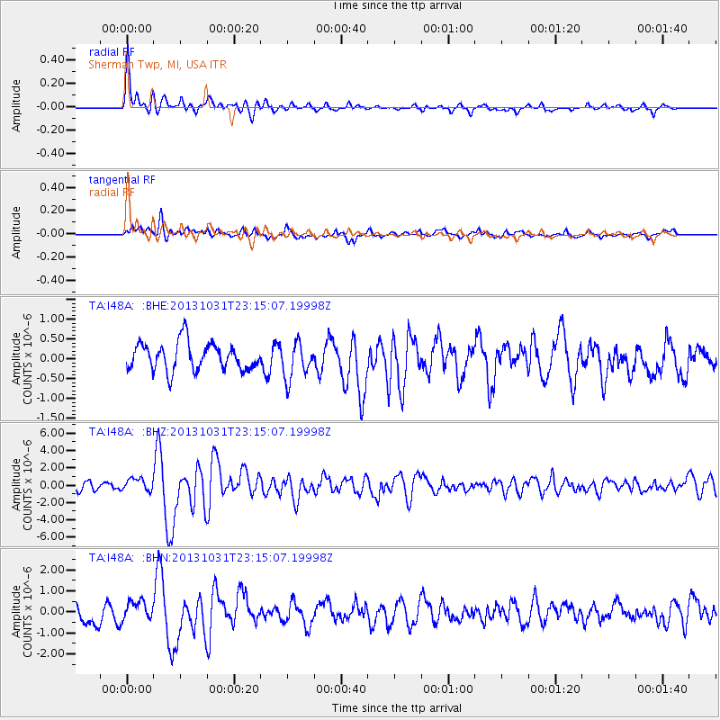
I48A Sherman Twp, MI, USA - Earthquake Result Viewer

Earthquake location: Near Coast Of Central Chile
Earthquake latitude/longitude: -30.3/-71.5
Earthquake time(UTC): 2013/10/31 (304) 23:03:59 GMT
Earthquake Depth: 27 km
Earthquake Magnitude: 6.6 MWW, 6.4 MWB, 6.5 MWC, 6.6 MWW, 6.6 MI
Earthquake Catalog/Contributor: NEIC PDE/NEIC COMCAT
Network: TA USArray Transportable Network (new EarthScope stations)
Station: I48A Sherman Twp, MI, USA
Lat/Lon: 44.19 N/83.70 W
Elevation: 192 m
Distance: 75.0 deg
Az: 350.957 deg
Baz: 169.107 deg
Ray Param: 0.051954404
Estimated Moho Depth: 47.25 km
Estimated Crust Vp/Vs: 1.65
Assumed Crust Vp: 6.483 km/s
Estimated Crust Vs: 3.923 km/s
Estimated Crust Poisson's Ratio: 0.21
Radial Match: 84.95217 %
Radial Bump: 400
Transverse Match: 63.270096 %
Transverse Bump: 400
SOD ConfigId: 626651
Insert Time: 2014-04-19 09:13:37.498 +0000
GWidth: 2.5
Max Bumps: 400
Tol: 0.001

Signal To Noise

ChannelStoNSTALTA
TA:I48A: :BHZ:20131031T23:15:07.19998Z1.68877297.188195E-74.2564602E-7
TA:I48A: :BHN:20131031T23:15:07.19998Z1.16407364.8627015E-74.1773146E-7
TA:I48A: :BHE:20131031T23:15:07.19998Z1.31930954.5972672E-73.4846008E-7
Arrivals
Ps4.9 SECOND
PpPs19 SECOND
PsPs/PpSs24 SECOND