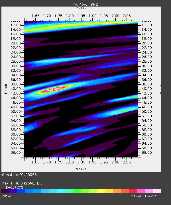
I49A Point Hope, MI, USA - Earthquake Result Viewer

Earthquake location: Near Coast Of Central Chile
Earthquake latitude/longitude: -30.3/-71.5
Earthquake time(UTC): 2013/10/31 (304) 23:03:59 GMT
Earthquake Depth: 27 km
Earthquake Magnitude: 6.6 MWW, 6.4 MWB, 6.5 MWC, 6.6 MWW, 6.6 MI
Earthquake Catalog/Contributor: NEIC PDE/NEIC COMCAT
Network: TA USArray Transportable Network (new EarthScope stations)
Station: I49A Point Hope, MI, USA
Lat/Lon: 43.94 N/82.82 W
Elevation: 217 m
Distance: 74.6 deg
Az: 351.555 deg
Baz: 169.872 deg
Ray Param: 0.05219393
Estimated Moho Depth: 40.0 km
Estimated Crust Vp/Vs: 1.73
Assumed Crust Vp: 6.483 km/s
Estimated Crust Vs: 3.753 km/s
Estimated Crust Poisson's Ratio: 0.25
Radial Match: 91.98065 %
Radial Bump: 372
Transverse Match: 74.00677 %
Transverse Bump: 400
SOD ConfigId: 626651
Insert Time: 2014-04-19 09:13:39.986 +0000
GWidth: 2.5
Max Bumps: 400
Tol: 0.001

Signal To Noise

ChannelStoNSTALTA
TA:I49A: :BHZ:20131031T23:15:05.125029Z2.38576138.311842E-73.483937E-7
TA:I49A: :BHN:20131031T23:15:05.125029Z1.53828853.596796E-72.3381804E-7
TA:I49A: :BHE:20131031T23:15:05.125029Z0.89391182.4710653E-72.764328E-7
Arrivals
Ps4.6 SECOND
PpPs16 SECOND
PsPs/PpSs21 SECOND