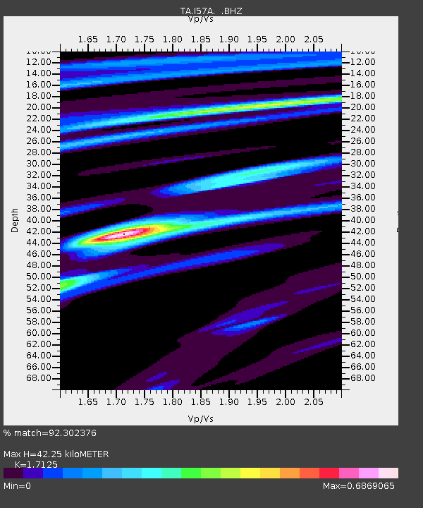
I57A Carthage, NY, USA - Earthquake Result Viewer

Earthquake location: Near Coast Of Central Chile
Earthquake latitude/longitude: -30.3/-71.5
Earthquake time(UTC): 2013/10/31 (304) 23:03:59 GMT
Earthquake Depth: 27 km
Earthquake Magnitude: 6.6 MWW, 6.4 MWB, 6.5 MWC, 6.6 MWW, 6.6 MI
Earthquake Catalog/Contributor: NEIC PDE/NEIC COMCAT
Network: TA USArray Transportable Network (new EarthScope stations)
Station: I57A Carthage, NY, USA
Lat/Lon: 43.94 N/75.66 W
Elevation: 321 m
Distance: 74.0 deg
Az: 356.891 deg
Baz: 176.276 deg
Ray Param: 0.052614935
Estimated Moho Depth: 42.25 km
Estimated Crust Vp/Vs: 1.71
Assumed Crust Vp: 6.419 km/s
Estimated Crust Vs: 3.748 km/s
Estimated Crust Poisson's Ratio: 0.24
Radial Match: 92.302376 %
Radial Bump: 313
Transverse Match: 75.920105 %
Transverse Bump: 400
SOD ConfigId: 626651
Insert Time: 2014-04-19 09:13:51.836 +0000
GWidth: 2.5
Max Bumps: 400
Tol: 0.001

Signal To Noise

ChannelStoNSTALTA
TA:I57A: :BHZ:20131031T23:15:01.475005Z3.26001797.171013E-72.1996851E-7
TA:I57A: :BHN:20131031T23:15:01.475005Z2.36437232.864322E-71.2114513E-7
TA:I57A: :BHE:20131031T23:15:01.475005Z1.20313871.6778195E-71.3945353E-7
Arrivals
Ps4.9 SECOND
PpPs17 SECOND
PsPs/PpSs22 SECOND