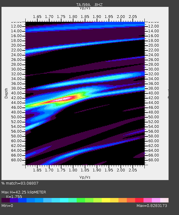
I59A Olmsteadville, NY, USA - Earthquake Result Viewer
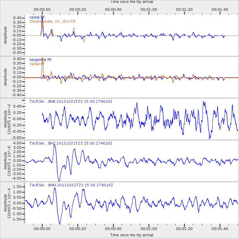
Earthquake location: Near Coast Of Central Chile
Earthquake latitude/longitude: -30.3/-71.5
Earthquake time(UTC): 2013/10/31 (304) 23:03:59 GMT
Earthquake Depth: 27 km
Earthquake Magnitude: 6.6 MWW, 6.4 MWB, 6.5 MWC, 6.6 MWW, 6.6 MI
Earthquake Catalog/Contributor: NEIC PDE/NEIC COMCAT
Network: TA USArray Transportable Network (new EarthScope stations)
Station: I59A Olmsteadville, NY, USA
Lat/Lon: 43.80 N/73.87 W
Elevation: 390 m
Distance: 73.8 deg
Az: 358.226 deg
Baz: 177.88 deg
Ray Param: 0.0527544
Estimated Moho Depth: 42.25 km
Estimated Crust Vp/Vs: 1.75
Assumed Crust Vp: 6.419 km/s
Estimated Crust Vs: 3.658 km/s
Estimated Crust Poisson's Ratio: 0.26
Radial Match: 83.06807 %
Radial Bump: 350
Transverse Match: 72.75033 %
Transverse Bump: 400
SOD ConfigId: 626651
Insert Time: 2014-04-19 09:13:56.691 +0000
GWidth: 2.5
Max Bumps: 400
Tol: 0.001

Signal To Noise

ChannelStoNSTALTA
TA:I59A: :BHZ:20131031T23:15:00.274016Z2.40244415.4638684E-72.2742957E-7
TA:I59A: :BHN:20131031T23:15:00.274016Z1.41047643.3939568E-72.4062484E-7
TA:I59A: :BHE:20131031T23:15:00.274016Z1.0579531.5009036E-71.4186864E-7
Arrivals
Ps5.1 SECOND
PpPs18 SECOND
PsPs/PpSs23 SECOND