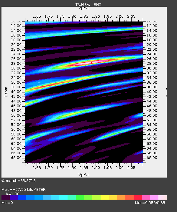
I63A Otisfield, ME, USA - Earthquake Result Viewer

Earthquake location: Near Coast Of Central Chile
Earthquake latitude/longitude: -30.3/-71.5
Earthquake time(UTC): 2013/10/31 (304) 23:03:59 GMT
Earthquake Depth: 27 km
Earthquake Magnitude: 6.6 MWW, 6.4 MWB, 6.5 MWC, 6.6 MWW, 6.6 MI
Earthquake Catalog/Contributor: NEIC PDE/NEIC COMCAT
Network: TA USArray Transportable Network (new EarthScope stations)
Station: I63A Otisfield, ME, USA
Lat/Lon: 44.05 N/70.58 W
Elevation: 177 m
Distance: 74.0 deg
Az: 0.706 deg
Baz: 180.846 deg
Ray Param: 0.052601073
Estimated Moho Depth: 27.25 km
Estimated Crust Vp/Vs: 1.88
Assumed Crust Vp: 6.419 km/s
Estimated Crust Vs: 3.414 km/s
Estimated Crust Poisson's Ratio: 0.30
Radial Match: 88.3716 %
Radial Bump: 323
Transverse Match: 67.012596 %
Transverse Bump: 400
SOD ConfigId: 626651
Insert Time: 2014-04-19 09:14:08.042 +0000
GWidth: 2.5
Max Bumps: 400
Tol: 0.001

Signal To Noise

ChannelStoNSTALTA
TA:I63A: :BHZ:20131031T23:15:01.600005Z3.29885448.5372824E-72.5879538E-7
TA:I63A: :BHN:20131031T23:15:01.600005Z1.27709213.5777742E-72.8015006E-7
TA:I63A: :BHE:20131031T23:15:01.600005Z0.48950291.2931038E-72.6416672E-7
Arrivals
Ps3.9 SECOND
PpPs12 SECOND
PsPs/PpSs16 SECOND