J61A Chester, VT, USA - Earthquake Result Viewer
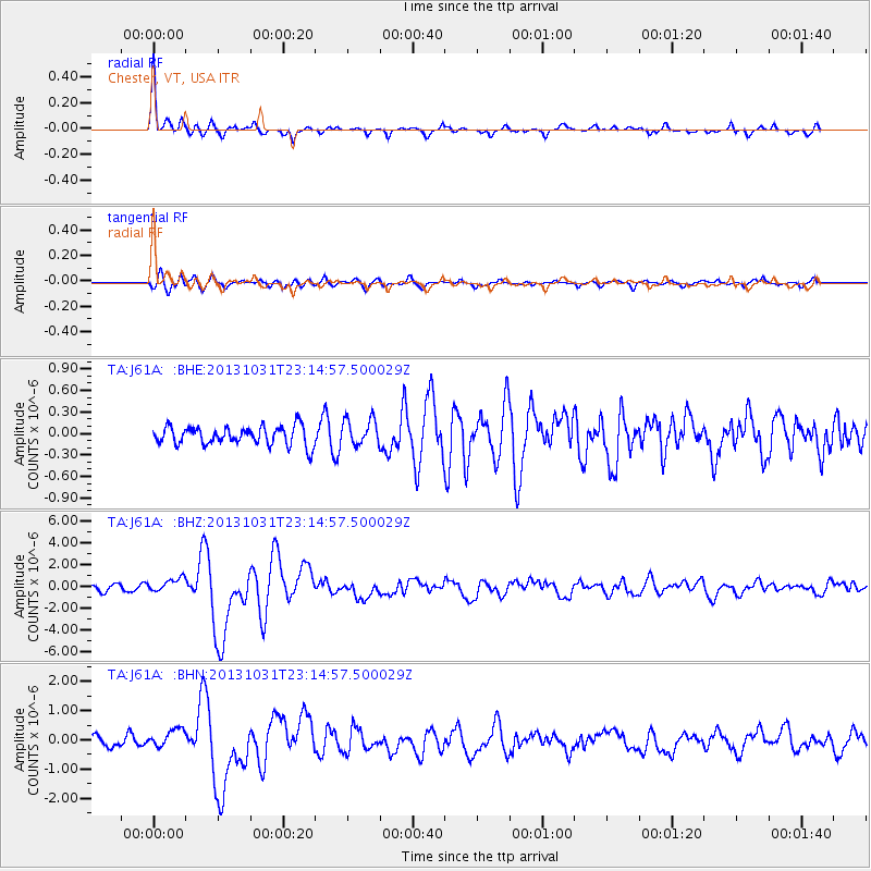
Earthquake location: Near Coast Of Central Chile
Earthquake latitude/longitude: -30.3/-71.5
Earthquake time(UTC): 2013/10/31 (304) 23:03:59 GMT
Earthquake Depth: 27 km
Earthquake Magnitude: 6.6 MWW, 6.4 MWB, 6.5 MWC, 6.6 MWW, 6.6 MI
Earthquake Catalog/Contributor: NEIC PDE/NEIC COMCAT
Network: TA USArray Transportable Network (new EarthScope stations)
Station: J61A Chester, VT, USA
Lat/Lon: 43.35 N/72.55 W
Elevation: 253 m
Distance: 73.3 deg
Az: 359.214 deg
Baz: 179.068 deg
Ray Param: 0.053070832
Estimated Moho Depth: 62.5 km
Estimated Crust Vp/Vs: 1.89
Assumed Crust Vp: 6.419 km/s
Estimated Crust Vs: 3.387 km/s
Estimated Crust Poisson's Ratio: 0.31
Radial Match: 89.96735 %
Radial Bump: 367
Transverse Match: 74.95459 %
Transverse Bump: 400
SOD ConfigId: 626651
Insert Time: 2014-04-19 09:14:48.730 +0000
GWidth: 2.5
Max Bumps: 400
Tol: 0.001

Signal To Noise

ChannelStoNSTALTA
TA:J61A: :BHZ:20131031T23:14:57.500029Z2.25694736.403344E-72.8371701E-7
TA:J61A: :BHN:20131031T23:14:57.500029Z1.54126133.1812482E-72.0640549E-7
TA:J61A: :BHE:20131031T23:14:57.500029Z1.44144921.8496615E-71.2831958E-7
Arrivals
Ps9.0 SECOND
PpPs27 SECOND
PsPs/PpSs36 SECOND