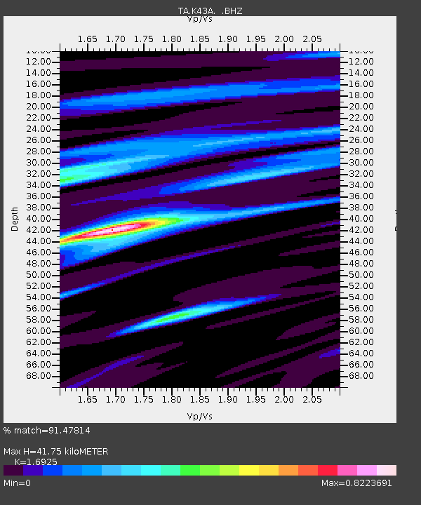
K43A Burlington, WI, USA - Earthquake Result Viewer

Earthquake location: Near Coast Of Central Chile
Earthquake latitude/longitude: -30.3/-71.5
Earthquake time(UTC): 2013/10/31 (304) 23:03:59 GMT
Earthquake Depth: 27 km
Earthquake Magnitude: 6.6 MWW, 6.4 MWB, 6.5 MWC, 6.6 MWW, 6.6 MI
Earthquake Catalog/Contributor: NEIC PDE/NEIC COMCAT
Network: TA USArray Transportable Network (new EarthScope stations)
Station: K43A Burlington, WI, USA
Lat/Lon: 42.70 N/88.33 W
Elevation: 264 m
Distance: 74.3 deg
Az: 347.204 deg
Baz: 164.937 deg
Ray Param: 0.052414313
Estimated Moho Depth: 41.75 km
Estimated Crust Vp/Vs: 1.69
Assumed Crust Vp: 6.571 km/s
Estimated Crust Vs: 3.882 km/s
Estimated Crust Poisson's Ratio: 0.23
Radial Match: 91.47814 %
Radial Bump: 309
Transverse Match: 68.40981 %
Transverse Bump: 400
SOD ConfigId: 626651
Insert Time: 2014-04-19 09:15:04.247 +0000
GWidth: 2.5
Max Bumps: 400
Tol: 0.001

Signal To Noise

ChannelStoNSTALTA
TA:K43A: :BHZ:20131031T23:15:03.225005Z4.2388138.173068E-71.9281501E-7
TA:K43A: :BHN:20131031T23:15:03.225005Z1.57381863.3472875E-72.1268573E-7
TA:K43A: :BHE:20131031T23:15:03.225005Z1.19787542.842505E-72.3729555E-7
Arrivals
Ps4.6 SECOND
PpPs16 SECOND
PsPs/PpSs21 SECOND