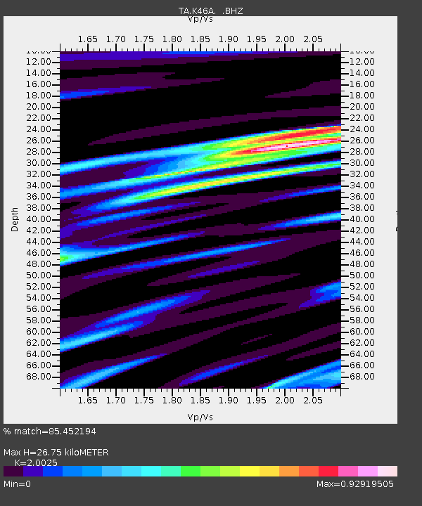
K46A Dorr, MI, USA - Earthquake Result Viewer
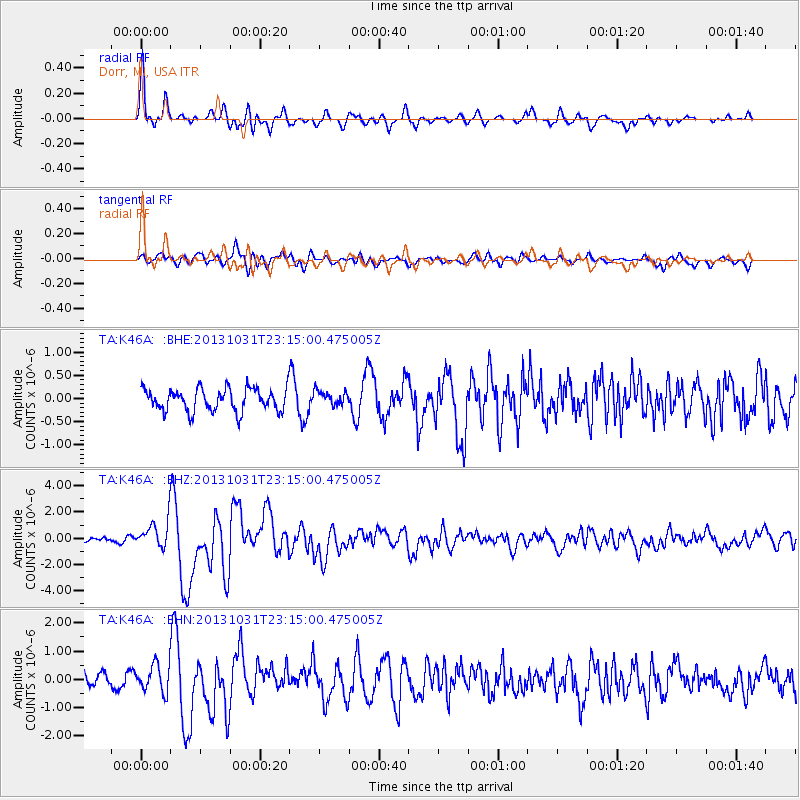
Earthquake location: Near Coast Of Central Chile
Earthquake latitude/longitude: -30.3/-71.5
Earthquake time(UTC): 2013/10/31 (304) 23:03:59 GMT
Earthquake Depth: 27 km
Earthquake Magnitude: 6.6 MWW, 6.4 MWB, 6.5 MWC, 6.6 MWW, 6.6 MI
Earthquake Catalog/Contributor: NEIC PDE/NEIC COMCAT
Network: TA USArray Transportable Network (new EarthScope stations)
Station: K46A Dorr, MI, USA
Lat/Lon: 42.69 N/85.78 W
Elevation: 213 m
Distance: 73.8 deg
Az: 349.096 deg
Baz: 167.18 deg
Ray Param: 0.052730188
Estimated Moho Depth: 26.75 km
Estimated Crust Vp/Vs: 2.00
Assumed Crust Vp: 6.483 km/s
Estimated Crust Vs: 3.237 km/s
Estimated Crust Poisson's Ratio: 0.33
Radial Match: 85.452194 %
Radial Bump: 400
Transverse Match: 63.922504 %
Transverse Bump: 400
SOD ConfigId: 626651
Insert Time: 2014-04-19 09:15:05.902 +0000
GWidth: 2.5
Max Bumps: 400
Tol: 0.001

Signal To Noise

ChannelStoNSTALTA
TA:K46A: :BHZ:20131031T23:15:00.475005Z3.80609131.0599239E-62.7848094E-7
TA:K46A: :BHN:20131031T23:15:00.475005Z2.19375354.867526E-72.2188117E-7
TA:K46A: :BHE:20131031T23:15:00.475005Z0.63305911.5405296E-72.4334688E-7
Arrivals
Ps4.3 SECOND
PpPs12 SECOND
PsPs/PpSs16 SECOND