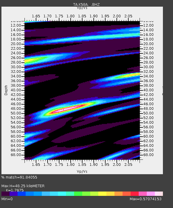
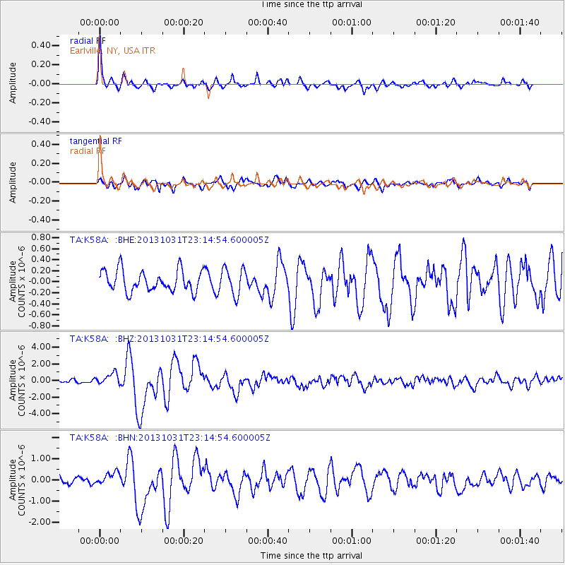
K58A Earlville, NY, USA - Earthquake Result Viewer

Earthquake location: Near Coast Of Central Chile
Earthquake latitude/longitude: -30.3/-71.5
Earthquake time(UTC): 2013/10/31 (304) 23:03:59 GMT
Earthquake Depth: 27 km
Earthquake Magnitude: 6.6 MWW, 6.4 MWB, 6.5 MWC, 6.6 MWW, 6.6 MI
Earthquake Catalog/Contributor: NEIC PDE/NEIC COMCAT
Network: TA USArray Transportable Network (new EarthScope stations)
Station: K58A Earlville, NY, USA
Lat/Lon: 42.76 N/75.65 W
Elevation: 509 m
Distance: 72.8 deg
Az: 356.82 deg
Baz: 176.265 deg
Ray Param: 0.05339117
Estimated Moho Depth: 48.25 km
Estimated Crust Vp/Vs: 1.77
Assumed Crust Vp: 6.419 km/s
Estimated Crust Vs: 3.632 km/s
Estimated Crust Poisson's Ratio: 0.26
Radial Match: 91.84055 %
Radial Bump: 373
Transverse Match: 76.93409 %
Transverse Bump: 400
SOD ConfigId: 626651
Insert Time: 2014-04-19 09:15:33.985 +0000
GWidth: 2.5
Max Bumps: 400
Tol: 0.001

Signal To Noise

ChannelStoNSTALTA
TA:K58A: :BHZ:20131031T23:14:54.600005Z3.4546937.2529616E-72.0994517E-7
TA:K58A: :BHN:20131031T23:14:54.600005Z1.43634742.853749E-71.9868098E-7
TA:K58A: :BHE:20131031T23:14:54.600005Z1.32581262.5196434E-71.9004521E-7
Arrivals
Ps6.0 SECOND
PpPs20 SECOND
PsPs/PpSs26 SECOND