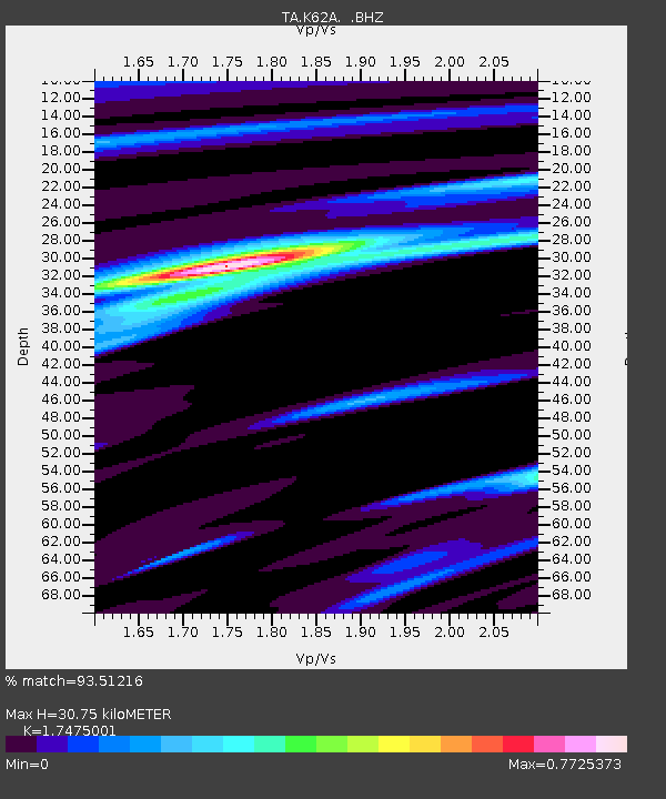
K62A Royalston, MA, USA - Earthquake Result Viewer
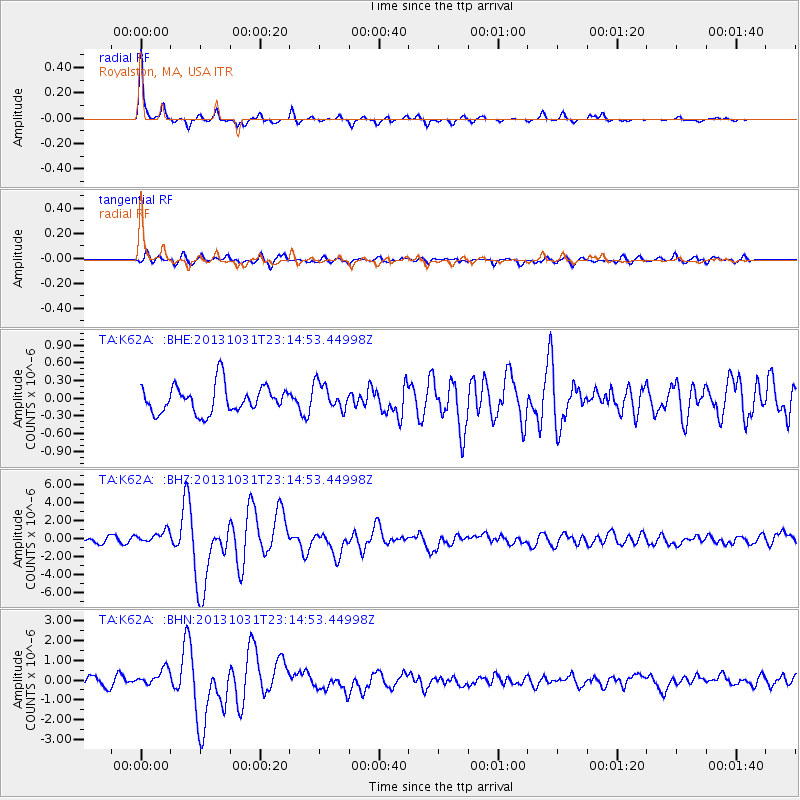
Earthquake location: Near Coast Of Central Chile
Earthquake latitude/longitude: -30.3/-71.5
Earthquake time(UTC): 2013/10/31 (304) 23:03:59 GMT
Earthquake Depth: 27 km
Earthquake Magnitude: 6.6 MWW, 6.4 MWB, 6.5 MWC, 6.6 MWW, 6.6 MI
Earthquake Catalog/Contributor: NEIC PDE/NEIC COMCAT
Network: TA USArray Transportable Network (new EarthScope stations)
Station: K62A Royalston, MA, USA
Lat/Lon: 42.67 N/72.23 W
Elevation: 289 m
Distance: 72.6 deg
Az: 359.449 deg
Baz: 179.354 deg
Ray Param: 0.053518344
Estimated Moho Depth: 30.75 km
Estimated Crust Vp/Vs: 1.75
Assumed Crust Vp: 6.419 km/s
Estimated Crust Vs: 3.673 km/s
Estimated Crust Poisson's Ratio: 0.26
Radial Match: 93.51216 %
Radial Bump: 210
Transverse Match: 71.750595 %
Transverse Bump: 400
SOD ConfigId: 626651
Insert Time: 2014-04-19 09:15:43.678 +0000
GWidth: 2.5
Max Bumps: 400
Tol: 0.001

Signal To Noise

ChannelStoNSTALTA
TA:K62A: :BHZ:20131031T23:14:53.44998Z2.76394947.080128E-72.5615984E-7
TA:K62A: :BHN:20131031T23:14:53.44998Z2.21666074.321915E-71.9497413E-7
TA:K62A: :BHE:20131031T23:14:53.44998Z0.96962742.248718E-72.3191569E-7
Arrivals
Ps3.7 SECOND
PpPs13 SECOND
PsPs/PpSs16 SECOND