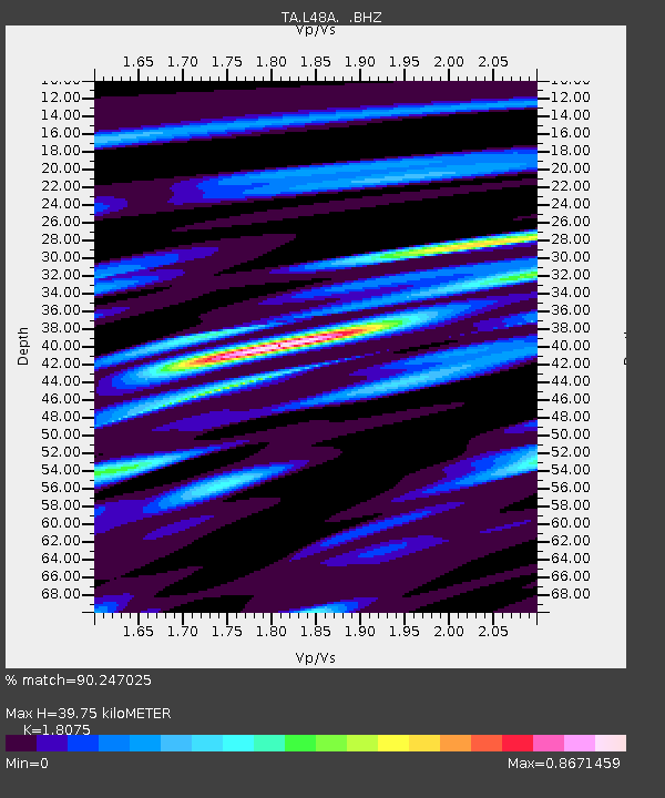
L48A N Adams, MI, USA - Earthquake Result Viewer
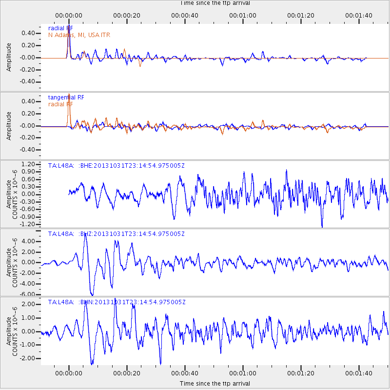
Earthquake location: Near Coast Of Central Chile
Earthquake latitude/longitude: -30.3/-71.5
Earthquake time(UTC): 2013/10/31 (304) 23:03:59 GMT
Earthquake Depth: 27 km
Earthquake Magnitude: 6.6 MWW, 6.4 MWB, 6.5 MWC, 6.6 MWW, 6.6 MI
Earthquake Catalog/Contributor: NEIC PDE/NEIC COMCAT
Network: TA USArray Transportable Network (new EarthScope stations)
Station: L48A N Adams, MI, USA
Lat/Lon: 41.94 N/84.43 W
Elevation: 369 m
Distance: 72.9 deg
Az: 349.954 deg
Baz: 168.332 deg
Ray Param: 0.05335003
Estimated Moho Depth: 39.75 km
Estimated Crust Vp/Vs: 1.81
Assumed Crust Vp: 6.498 km/s
Estimated Crust Vs: 3.595 km/s
Estimated Crust Poisson's Ratio: 0.28
Radial Match: 90.247025 %
Radial Bump: 400
Transverse Match: 69.17472 %
Transverse Bump: 400
SOD ConfigId: 626651
Insert Time: 2014-04-19 09:16:07.002 +0000
GWidth: 2.5
Max Bumps: 400
Tol: 0.001

Signal To Noise

ChannelStoNSTALTA
TA:L48A: :BHZ:20131031T23:14:54.975005Z3.52382568.692387E-72.4667472E-7
TA:L48A: :BHN:20131031T23:14:54.975005Z2.30450964.1520394E-71.8017019E-7
TA:L48A: :BHE:20131031T23:14:54.975005Z0.82203381.9584131E-72.3823996E-7
Arrivals
Ps5.1 SECOND
PpPs17 SECOND
PsPs/PpSs22 SECOND