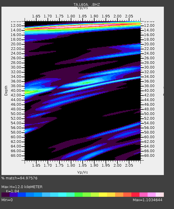
L60A Shokan, NY, USA - Earthquake Result Viewer
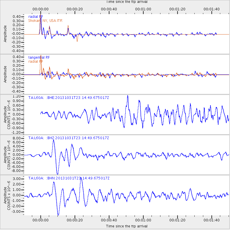
Earthquake location: Near Coast Of Central Chile
Earthquake latitude/longitude: -30.3/-71.5
Earthquake time(UTC): 2013/10/31 (304) 23:03:59 GMT
Earthquake Depth: 27 km
Earthquake Magnitude: 6.6 MWW, 6.4 MWB, 6.5 MWC, 6.6 MWW, 6.6 MI
Earthquake Catalog/Contributor: NEIC PDE/NEIC COMCAT
Network: TA USArray Transportable Network (new EarthScope stations)
Station: L60A Shokan, NY, USA
Lat/Lon: 41.99 N/74.22 W
Elevation: 388 m
Distance: 72.0 deg
Az: 357.883 deg
Baz: 177.543 deg
Ray Param: 0.05393983
Estimated Moho Depth: 12.0 km
Estimated Crust Vp/Vs: 1.84
Assumed Crust Vp: 6.283 km/s
Estimated Crust Vs: 3.415 km/s
Estimated Crust Poisson's Ratio: 0.29
Radial Match: 94.97576 %
Radial Bump: 400
Transverse Match: 81.32728 %
Transverse Bump: 400
SOD ConfigId: 626651
Insert Time: 2014-04-19 09:16:32.338 +0000
GWidth: 2.5
Max Bumps: 400
Tol: 0.001

Signal To Noise

ChannelStoNSTALTA
TA:L60A: :BHZ:20131031T23:14:49.675017Z2.58396398.276043E-73.2028478E-7
TA:L60A: :BHN:20131031T23:14:49.675017Z1.37873233.220433E-72.3357927E-7
TA:L60A: :BHE:20131031T23:14:49.675017Z1.73681722.3695696E-71.3643172E-7
Arrivals
Ps1.7 SECOND
PpPs5.3 SECOND
PsPs/PpSs6.9 SECOND