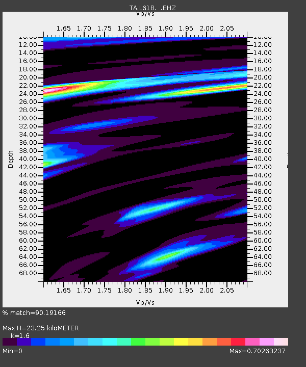
L61B Northampton, MA, USA - Earthquake Result Viewer

Earthquake location: Near Coast Of Central Chile
Earthquake latitude/longitude: -30.3/-71.5
Earthquake time(UTC): 2013/10/31 (304) 23:03:59 GMT
Earthquake Depth: 27 km
Earthquake Magnitude: 6.6 MWW, 6.4 MWB, 6.5 MWC, 6.6 MWW, 6.6 MI
Earthquake Catalog/Contributor: NEIC PDE/NEIC COMCAT
Network: TA USArray Transportable Network (new EarthScope stations)
Station: L61B Northampton, MA, USA
Lat/Lon: 42.45 N/72.68 W
Elevation: 261 m
Distance: 72.4 deg
Az: 359.1 deg
Baz: 178.949 deg
Ray Param: 0.05365603
Estimated Moho Depth: 23.25 km
Estimated Crust Vp/Vs: 1.60
Assumed Crust Vp: 6.419 km/s
Estimated Crust Vs: 4.012 km/s
Estimated Crust Poisson's Ratio: 0.18
Radial Match: 90.19166 %
Radial Bump: 332
Transverse Match: 74.17139 %
Transverse Bump: 400
SOD ConfigId: 626651
Insert Time: 2014-04-19 09:16:37.193 +0000
GWidth: 2.5
Max Bumps: 400
Tol: 0.001

Signal To Noise

ChannelStoNSTALTA
TA:L61B: :BHZ:20131031T23:14:52.19998Z2.77840077.1474034E-72.5724884E-7
TA:L61B: :BHN:20131031T23:14:52.19998Z2.86700734.0475487E-71.4117678E-7
TA:L61B: :BHE:20131031T23:14:52.19998Z0.38893259.0248285E-82.3204099E-7
Arrivals
Ps2.3 SECOND
PpPs9.1 SECOND
PsPs/PpSs11 SECOND