You are here: Home > Network List > TA - USArray Transportable Network (new EarthScope stations) Stations List
> Station D03D Eldon, WA, USA > Earthquake Result Viewer
D03D Eldon, WA, USA - Earthquake Result Viewer
| Earthquake location: |
Solomon Islands |
| Earthquake latitude/longitude: |
-6.8/154.3 |
| Earthquake time(UTC): |
2014/12/07 (341) 02:24:32 GMT |
| Earthquake Depth: |
10 km |
| Earthquake Magnitude: |
5.0 mb |
| Earthquake Catalog/Contributor: |
ISC/ISC |
|
| Network: |
TA USArray Transportable Network (new EarthScope stations) |
| Station: |
D03D Eldon, WA, USA |
| Lat/Lon: |
47.53 N/123.09 W |
| Elevation: |
262 m |
|
| Distance: |
90.0 deg |
| Az: |
42.22 deg |
| Baz: |
260.014 deg |
| Ray Param: |
0.041706298 |
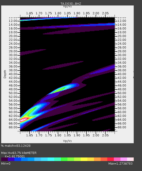
| Estimated Moho Depth: |
63.75 km |
| Estimated Crust Vp/Vs: |
1.62 |
| Assumed Crust Vp: |
6.566 km/s |
| Estimated Crust Vs: |
4.059 km/s |
| Estimated Crust Poisson's Ratio: |
0.19 |
|
| Radial Match: |
83.12428 % |
| Radial Bump: |
398 |
| Transverse Match: |
59.727806 % |
| Transverse Bump: |
400 |
| SOD ConfigId: |
3390531 |
| Insert Time: |
2019-04-15 09:54:18.040 +0000 |
| GWidth: |
2.5 |
| Max Bumps: |
400 |
| Tol: |
0.001 |
|

Signal To Noise
| Channel | StoN | STA | LTA |
| TA:D03D: :BHZ:20141207T02:37:00.674988Z | 1.4136198 | 1.5387426E-6 | 1.0885124E-6 |
| TA:D03D: :BHN:20141207T02:37:00.674988Z | 1.2835044 | 6.0711005E-7 | 4.7300972E-7 |
| TA:D03D: :BHE:20141207T02:37:00.674988Z | 1.7728657 | 2.0590549E-6 | 1.1614275E-6 |
| Arrivals |
| Ps | 6.1 SECOND |
| PpPs | 25 SECOND |
| PsPs/PpSs | 31 SECOND |


