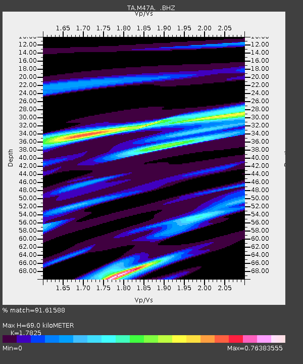
M47A Cromwell, IN, USA - Earthquake Result Viewer
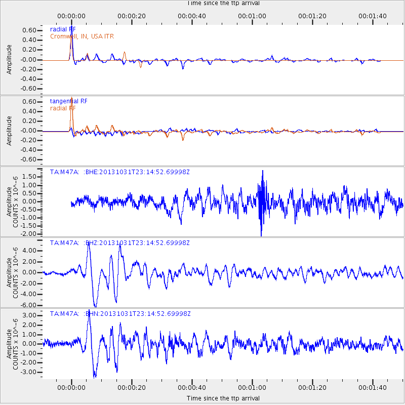
Earthquake location: Near Coast Of Central Chile
Earthquake latitude/longitude: -30.3/-71.5
Earthquake time(UTC): 2013/10/31 (304) 23:03:59 GMT
Earthquake Depth: 27 km
Earthquake Magnitude: 6.6 MWW, 6.4 MWB, 6.5 MWC, 6.6 MWW, 6.6 MI
Earthquake Catalog/Contributor: NEIC PDE/NEIC COMCAT
Network: TA USArray Transportable Network (new EarthScope stations)
Station: M47A Cromwell, IN, USA
Lat/Lon: 41.36 N/85.62 W
Elevation: 283 m
Distance: 72.5 deg
Az: 348.912 deg
Baz: 167.234 deg
Ray Param: 0.053600304
Estimated Moho Depth: 69.0 km
Estimated Crust Vp/Vs: 1.78
Assumed Crust Vp: 6.498 km/s
Estimated Crust Vs: 3.645 km/s
Estimated Crust Poisson's Ratio: 0.27
Radial Match: 91.61588 %
Radial Bump: 274
Transverse Match: 69.37184 %
Transverse Bump: 400
SOD ConfigId: 626651
Insert Time: 2014-04-19 09:16:53.904 +0000
GWidth: 2.5
Max Bumps: 400
Tol: 0.001

Signal To Noise

ChannelStoNSTALTA
TA:M47A: :BHZ:20131031T23:14:52.69998Z2.79112056.7837186E-72.430464E-7
TA:M47A: :BHN:20131031T23:14:52.69998Z1.62241724.2129054E-72.5966844E-7
TA:M47A: :BHE:20131031T23:14:52.69998Z2.16504844.4525243E-72.0565473E-7
Arrivals
Ps8.6 SECOND
PpPs29 SECOND
PsPs/PpSs37 SECOND