You are here: Home > Network List > TA - USArray Transportable Network (new EarthScope stations) Stations List
> Station O03E Paynes Creek, CA, USA > Earthquake Result Viewer
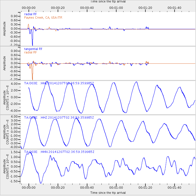
O03E Paynes Creek, CA, USA - Earthquake Result Viewer
*The percent match for this event was below the threshold and hence no stack was calculated.
| Earthquake location: |
Solomon Islands |
| Earthquake latitude/longitude: |
-6.8/154.3 |
| Earthquake time(UTC): |
2014/12/07 (341) 02:24:32 GMT |
| Earthquake Depth: |
10 km |
| Earthquake Magnitude: |
5.0 mb |
| Earthquake Catalog/Contributor: |
ISC/ISC |
|
| Network: |
TA USArray Transportable Network (new EarthScope stations) |
| Station: |
O03E Paynes Creek, CA, USA |
| Lat/Lon: |
40.29 N/121.80 W |
| Elevation: |
967 m |
|
| Distance: |
89.7 deg |
| Az: |
49.512 deg |
| Baz: |
260.926 deg |
| Ray Param: |
$rayparam |
*The percent match for this event was below the threshold and hence was not used in the summary stack. |
|
| Radial Match: |
97.7041 % |
| Radial Bump: |
190 |
| Transverse Match: |
78.73789 % |
| Transverse Bump: |
400 |
| SOD ConfigId: |
3390531 |
| Insert Time: |
2019-04-15 09:54:23.582 +0000 |
| GWidth: |
2.5 |
| Max Bumps: |
400 |
| Tol: |
0.001 |
|
Signal To Noise
| Channel | StoN | STA | LTA |
| TA:O03E: :HHZ:20141207T02:36:59.359985Z | 0.9783949 | 2.9123585E-6 | 2.9766697E-6 |
| TA:O03E: :HHN:20141207T02:36:59.359985Z | 1.4816642 | 1.3382346E-6 | 9.0319696E-7 |
| TA:O03E: :HHE:20141207T02:36:59.359985Z | 1.018931 | 2.8788193E-6 | 2.8253328E-6 |
| Arrivals |
| Ps | |
| PpPs | |
| PsPs/PpSs | |


