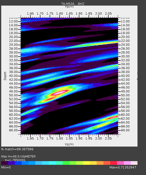
M52A Chesterland, OH, USA - Earthquake Result Viewer

Earthquake location: Near Coast Of Central Chile
Earthquake latitude/longitude: -30.3/-71.5
Earthquake time(UTC): 2013/10/31 (304) 23:03:59 GMT
Earthquake Depth: 27 km
Earthquake Magnitude: 6.6 MWW, 6.4 MWB, 6.5 MWC, 6.6 MWW, 6.6 MI
Earthquake Catalog/Contributor: NEIC PDE/NEIC COMCAT
Network: TA USArray Transportable Network (new EarthScope stations)
Station: M52A Chesterland, OH, USA
Lat/Lon: 41.54 N/81.36 W
Elevation: 382 m
Distance: 72.1 deg
Az: 352.253 deg
Baz: 171.065 deg
Ray Param: 0.053883463
Estimated Moho Depth: 48.5 km
Estimated Crust Vp/Vs: 1.80
Assumed Crust Vp: 6.483 km/s
Estimated Crust Vs: 3.611 km/s
Estimated Crust Poisson's Ratio: 0.27
Radial Match: 89.387596 %
Radial Bump: 400
Transverse Match: 65.06511 %
Transverse Bump: 400
SOD ConfigId: 626651
Insert Time: 2014-04-19 09:17:02.903 +0000
GWidth: 2.5
Max Bumps: 400
Tol: 0.001

Signal To Noise

ChannelStoNSTALTA
TA:M52A: :BHZ:20131031T23:14:50.175017Z3.59457258.939817E-72.487032E-7
TA:M52A: :BHN:20131031T23:14:50.175017Z1.81375095.550943E-73.0604772E-7
TA:M52A: :BHE:20131031T23:14:50.175017Z1.86900993.9565273E-72.1169109E-7
Arrivals
Ps6.2 SECOND
PpPs20 SECOND
PsPs/PpSs26 SECOND