You are here: Home > Network List > TA - USArray Transportable Network (new EarthScope stations) Stations List
> Station M53A WI Miller and Sons, Farmdale, OH, USA > Earthquake Result Viewer
M53A WI Miller and Sons, Farmdale, OH, USA - Earthquake Result Viewer
| Earthquake location: |
Near Coast Of Central Chile |
| Earthquake latitude/longitude: |
-30.3/-71.5 |
| Earthquake time(UTC): |
2013/10/31 (304) 23:03:59 GMT |
| Earthquake Depth: |
27 km |
| Earthquake Magnitude: |
6.6 MWW, 6.4 MWB, 6.5 MWC, 6.6 MWW, 6.6 MI |
| Earthquake Catalog/Contributor: |
NEIC PDE/NEIC COMCAT |
|
| Network: |
TA USArray Transportable Network (new EarthScope stations) |
| Station: |
M53A WI Miller and Sons, Farmdale, OH, USA |
| Lat/Lon: |
41.44 N/80.68 W |
| Elevation: |
334 m |
|
| Distance: |
71.9 deg |
| Az: |
352.77 deg |
| Baz: |
171.676 deg |
| Ray Param: |
0.05400159 |
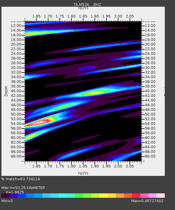
| Estimated Moho Depth: |
53.25 km |
| Estimated Crust Vp/Vs: |
1.66 |
| Assumed Crust Vp: |
6.483 km/s |
| Estimated Crust Vs: |
3.899 km/s |
| Estimated Crust Poisson's Ratio: |
0.22 |
|
| Radial Match: |
83.734116 % |
| Radial Bump: |
359 |
| Transverse Match: |
77.0523 % |
| Transverse Bump: |
400 |
| SOD ConfigId: |
626651 |
| Insert Time: |
2014-04-19 09:17:08.010 +0000 |
| GWidth: |
2.5 |
| Max Bumps: |
400 |
| Tol: |
0.001 |
|
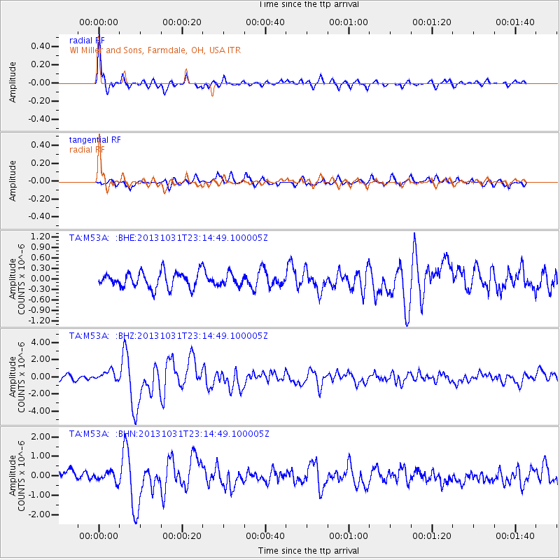
Signal To Noise
| Channel | StoN | STA | LTA |
| TA:M53A: :BHZ:20131031T23:14:49.100005Z | 1.8889334 | 6.3986806E-7 | 3.387457E-7 |
| TA:M53A: :BHN:20131031T23:14:49.100005Z | 0.78169286 | 2.7197794E-7 | 3.4793453E-7 |
| TA:M53A: :BHE:20131031T23:14:49.100005Z | 0.7335272 | 1.6628923E-7 | 2.266981E-7 |
| Arrivals |
| Ps | 5.7 SECOND |
| PpPs | 21 SECOND |
| PsPs/PpSs | 27 SECOND |


