You are here: Home > Network List > TA - USArray Transportable Network (new EarthScope stations) Stations List
> Station M58A Price's Panorama, Nuncy Valley, PA, USA > Earthquake Result Viewer
M58A Price's Panorama, Nuncy Valley, PA, USA - Earthquake Result Viewer

| Earthquake location: |
Near Coast Of Central Chile |
| Earthquake latitude/longitude: |
-30.3/-71.5 |
| Earthquake time(UTC): |
2013/10/31 (304) 23:03:59 GMT |
| Earthquake Depth: |
27 km |
| Earthquake Magnitude: |
6.6 MWW, 6.4 MWB, 6.5 MWC, 6.6 MWW, 6.6 MI |
| Earthquake Catalog/Contributor: |
NEIC PDE/NEIC COMCAT |
|
| Network: |
TA USArray Transportable Network (new EarthScope stations) |
| Station: |
M58A Price's Panorama, Nuncy Valley, PA, USA |
| Lat/Lon: |
41.37 N/76.46 W |
| Elevation: |
529 m |
|
| Distance: |
71.5 deg |
| Az: |
356.081 deg |
| Baz: |
175.495 deg |
| Ray Param: |
0.05428279 |
| Estimated Moho Depth: |
36.5 km |
| Estimated Crust Vp/Vs: |
1.80 |
| Assumed Crust Vp: |
6.121 km/s |
| Estimated Crust Vs: |
3.41 km/s |
| Estimated Crust Poisson's Ratio: |
0.27 |
|
| Radial Match: |
93.258446 % |
| Radial Bump: |
337 |
| Transverse Match: |
77.63852 % |
| Transverse Bump: |
400 |
| SOD ConfigId: |
626651 |
| Insert Time: |
2014-04-19 09:17:18.939 +0000 |
| GWidth: |
2.5 |
| Max Bumps: |
400 |
| Tol: |
0.001 |
|
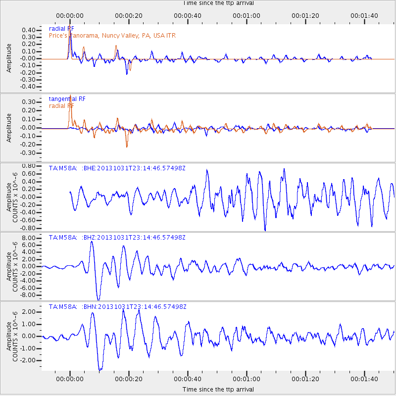
Signal To Noise
| Channel | StoN | STA | LTA |
| TA:M58A: :BHZ:20131031T23:14:46.57498Z | 2.6962488 | 7.943642E-7 | 2.946183E-7 |
| TA:M58A: :BHN:20131031T23:14:46.57498Z | 3.4573157 | 4.654807E-7 | 1.3463645E-7 |
| TA:M58A: :BHE:20131031T23:14:46.57498Z | 0.82137173 | 1.2757182E-7 | 1.5531556E-7 |
| Arrivals |
| Ps | 4.9 SECOND |
| PpPs | 16 SECOND |
| PsPs/PpSs | 21 SECOND |


