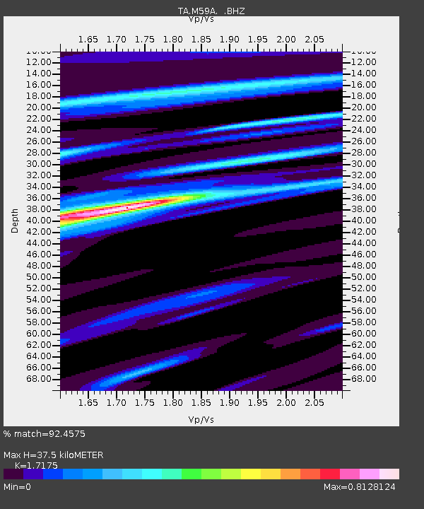
M59A Waymart, PA, USA - Earthquake Result Viewer
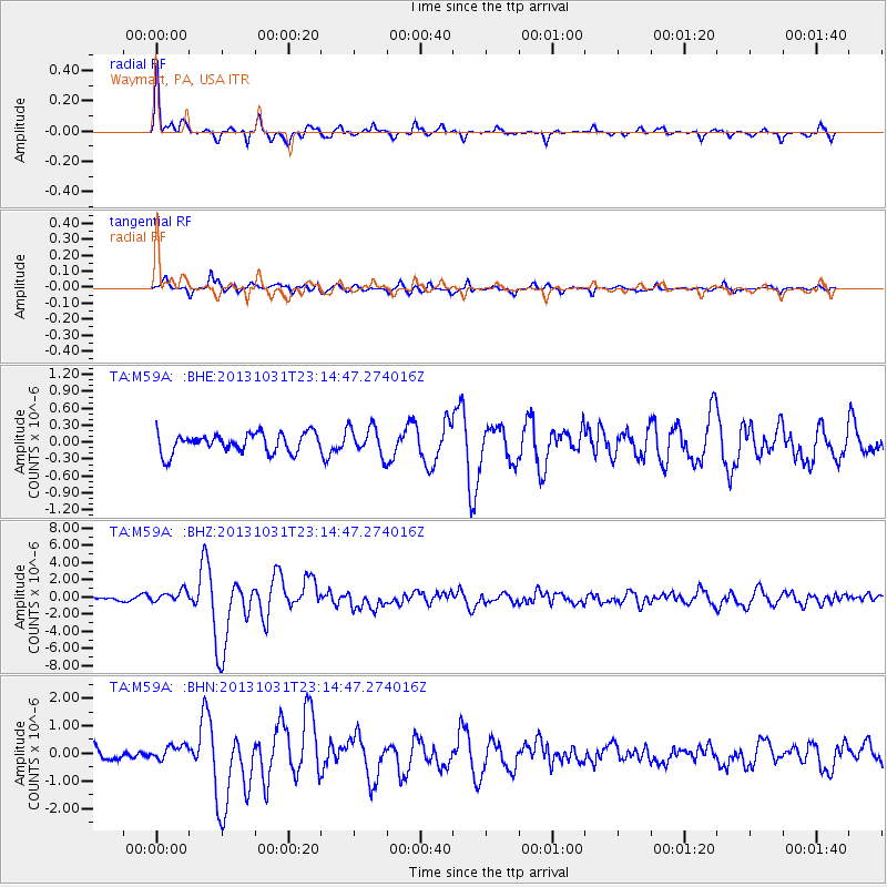
Earthquake location: Near Coast Of Central Chile
Earthquake latitude/longitude: -30.3/-71.5
Earthquake time(UTC): 2013/10/31 (304) 23:03:59 GMT
Earthquake Depth: 27 km
Earthquake Magnitude: 6.6 MWW, 6.4 MWB, 6.5 MWC, 6.6 MWW, 6.6 MI
Earthquake Catalog/Contributor: NEIC PDE/NEIC COMCAT
Network: TA USArray Transportable Network (new EarthScope stations)
Station: M59A Waymart, PA, USA
Lat/Lon: 41.54 N/75.43 W
Elevation: 471 m
Distance: 71.6 deg
Az: 356.907 deg
Baz: 176.435 deg
Ray Param: 0.054206472
Estimated Moho Depth: 37.5 km
Estimated Crust Vp/Vs: 1.72
Assumed Crust Vp: 6.283 km/s
Estimated Crust Vs: 3.658 km/s
Estimated Crust Poisson's Ratio: 0.24
Radial Match: 92.4575 %
Radial Bump: 322
Transverse Match: 79.43825 %
Transverse Bump: 400
SOD ConfigId: 626651
Insert Time: 2014-04-19 09:17:22.684 +0000
GWidth: 2.5
Max Bumps: 400
Tol: 0.001

Signal To Noise

ChannelStoNSTALTA
TA:M59A: :BHZ:20131031T23:14:47.274016Z2.34177736.804346E-72.9056332E-7
TA:M59A: :BHN:20131031T23:14:47.274016Z1.18808422.6257894E-72.2101035E-7
TA:M59A: :BHE:20131031T23:14:47.274016Z1.48601932.5548954E-71.7192883E-7
Arrivals
Ps4.4 SECOND
PpPs16 SECOND
PsPs/PpSs20 SECOND