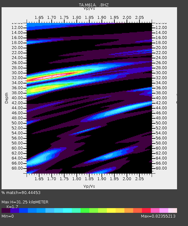
M61A Granite Springs, NY, USA - Earthquake Result Viewer

Earthquake location: Near Coast Of Central Chile
Earthquake latitude/longitude: -30.3/-71.5
Earthquake time(UTC): 2013/10/31 (304) 23:03:59 GMT
Earthquake Depth: 27 km
Earthquake Magnitude: 6.6 MWW, 6.4 MWB, 6.5 MWC, 6.6 MWW, 6.6 MI
Earthquake Catalog/Contributor: NEIC PDE/NEIC COMCAT
Network: TA USArray Transportable Network (new EarthScope stations)
Station: M61A Granite Springs, NY, USA
Lat/Lon: 41.31 N/73.77 W
Elevation: 190 m
Distance: 71.3 deg
Az: 358.214 deg
Baz: 177.949 deg
Ray Param: 0.054401346
Estimated Moho Depth: 31.25 km
Estimated Crust Vp/Vs: 1.70
Assumed Crust Vp: 6.472 km/s
Estimated Crust Vs: 3.807 km/s
Estimated Crust Poisson's Ratio: 0.24
Radial Match: 90.44453 %
Radial Bump: 384
Transverse Match: 78.56358 %
Transverse Bump: 400
SOD ConfigId: 626651
Insert Time: 2014-04-19 09:17:27.810 +0000
GWidth: 2.5
Max Bumps: 400
Tol: 0.001

Signal To Noise

ChannelStoNSTALTA
TA:M61A: :BHZ:20131031T23:14:45.524016Z3.28230867.5134943E-72.2890883E-7
TA:M61A: :BHN:20131031T23:14:45.524016Z1.35623743.1795994E-72.3444268E-7
TA:M61A: :BHE:20131031T23:14:45.524016Z0.825371441.5604596E-71.8906148E-7
Arrivals
Ps3.5 SECOND
PpPs13 SECOND
PsPs/PpSs16 SECOND